


The Met Office has named a storm system set to hit Britain this Easter weekend as Storm Dave, warning of strong winds and in some areas, patches of heavy snow.
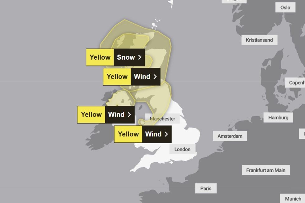
Yellow warnings for wind are in place across Scotland, Northern Ireland, northern Wales and parts of northern England.
The warnings will come into force on Saturday at 6pm and last until Sunday at midday.
A separate snow warning affecting the Highlands will also come into force at 3pm on Saturday and last until 3am on Sunday.
TRENDING
Stories
Videos
Your Say
The Met Office has warned 5-10cm of snow could fall in the warning area with accumulations of up to 20cm in some areas.
Deputy Chief Forecaster Tom Crabtree said: "People should prepare for strong winds and stay updated. Storm Dave will rapidly deepen on Saturday.
"Winds will strengthen significantly, with gusts of 60-70mph across Scotland and the potential for 80-90mph in exposed coastal areas.
"Northern Britain will see 50-60mph gusts more widely. Snowfall over northern Scottish hills could reach 10-20cm, causing blizzard conditions, while heavy rain spreads eastwards across the UK."
The Met Office was warned Storm Dave will bring 90mph winds and the possibility of snow
|MET OFFICE
Britain's national forecaster continued by warning that "snowy, wintry weather can cause delays and make driving conditions dangerous".
Drivers have been told to plan routes, check for delays and road closures, amend travel plans if necessary, and leave more time to prepare and check their car before setting off.
Britons have also been warned to prepare a few essentials in their car such as warm clothing, food, water, a blanket, a torch, ice scraper/de-icer, a warning triangle, high visibility vest and an in-car phone charger.
The Met Office snow warning reads: "Rain arriving from the south through Saturday afternoon is likely to turn to sleet and snow over hills as it meets cold air across central and northwest Scotland.
LATEST DEVELOPMENTS:
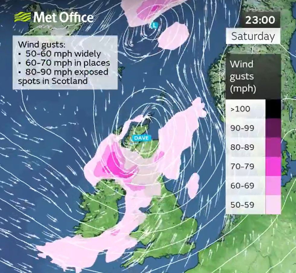
Met Office maps show 90mph wind gusts could be possible in coastal areas
|MET OFFICE
"During the evening snow may turn heavier and as winds increase, blizzard conditions with drifting and blowing snow likely to lead to very poor visibility across the hills and mountains of the northwest of Scotland.
"Accumulating snow on roads will mostly be above 200 m elevation, where 5-10 cm is possible and a small chance of 10-20 cm.
"As the area of snow clears to the northeast early Sunday, more scattered isolated sleet and snow showers will follow into Sunday daytime.
"These are unlikely to produce further accumulations."
Its wind warning continued: "A rapidly deepening area of low pressure, Storm Dave, is likely to move northeastwards close to or across northwestern parts of the UK during Saturday evening and night, clearing to the North Sea by Sunday.
"Whilst there is some uncertainty over the exact track, intensity and shape of this area of low pressure, a period of strong west to southwesterly winds is expected during Saturday night and into the first part of Easter Sunday, before gradually easing through the day.
"Peak gusts of 50-60 mph will be possible fairly widely, with 60-70 mph in more exposed locations.
"There is a slight chance of some very strong winds at times where gusts of 80-90 mph may be possible in exposed areas for a time.
"Large waves may lead to some dangerous conditions around windward coasts."