


America could be facing hurricane hell later this year with changes in ocean temperatures threatening a spate of deadly storms.
As the super El-Nino which set in last year wanes, sea waters will cool, possibly triggering a more active hurricane season, experts warn.
A rapid drop in temperatures would see El Nino, the result of ocean warming near South America, pendulum swing into La Nina.
Meaning ‘little girl’, La Nina is the opposite of El Nino and builds cooler waters off the South American coast.
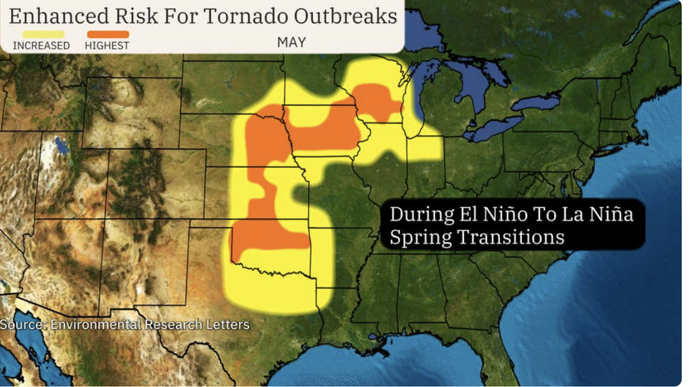
Risk of tornadoes across eastern states
|The Weather Channel
However, it is linked to unstable atmospheric conditions in the United States with fears it could fuel a barrage of hurricanes and tornadoes.
Weather Channel meteorologist Ari Sarsalari said: “It looks like we could move into a La Nina phase this summer, according to the Climate Prediction Centre.
“That means that we could be looking at a whole different sort of weather pattern by [autumn] and winter.
“If La Nina conditions were to develop, we would be looking at the possibility of more active wet weather in the northwest and the Midwest, and then drier conditions down in the southern US.
“The disappearance of El Nino conditions could lead to a more active hurricane season, but it is really difficult to predict this kind of thing so far out.
La Nina would bring a 55 per cent chance of a more serious hurricane season, a warmer than usual southern winter, and colder temperatures further north, he said.
LATEST DEVELOPMENTS:
- US weather: 'Blast of misery' to batter America as northeast pummelled by heavy snow
- US weather: Nor'easter snowstorm impacts 45 MILLION Americans as motorists warned of 'real trouble'
- US weather: Shape-shifting jet stream to send temperatures plummeting during 'winter assault' with parts of America bracing for major snowfall
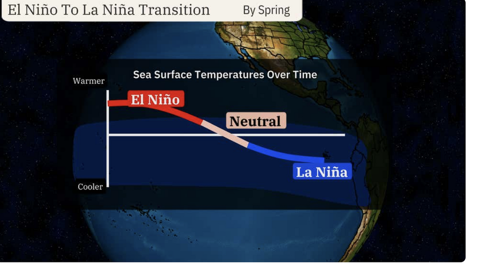
El Nino to weaken into La Nina this spring
|The Weather Channel
The strong El Nino which set in last summer has begun to die down as ocean temperatures return to normal, he added.
La Nina may also increase the tornado risk in the upper Midwest, pulling warm, moist and unstable air up from the Gulf of Mexico.
It may also boost the Atlantic basin’s ability to whip up hurricane conditions, A Weather Channel spokesperson added.
They said: “More trouble is likely ahead this hurricane season. La Nina typically does not cause the sinking air in the Caribbean that we saw last year.
“This should add up to the Atlantic being able to produce more tropical storms and hurricanes.”
An increased risk of hurricanes will depend on whether El Nino indeed transitions into La Nina, rather than fizzling out.
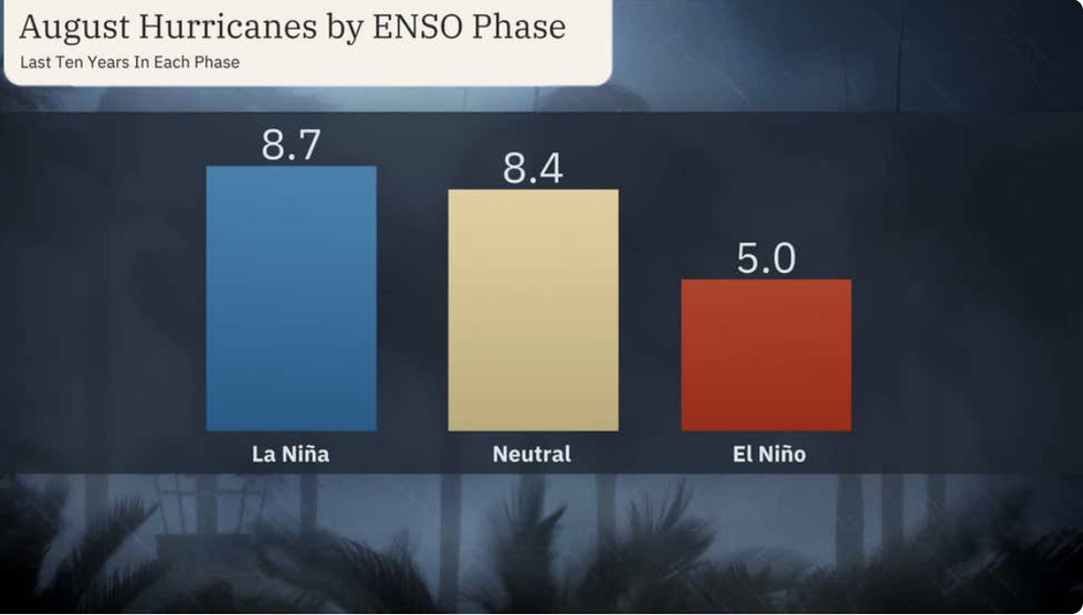
La Nina could bring an increased risk of hurricanes
|The Weather Channel
Jim Dale, US weather correspondent and meteorologist for British Weather Services, said: “This is going to be one to watch, because the transition from El Nino to La Nina will take time, so we are in unknown territory.
“If La Nina did develop, then we would see an increased risk of tropical storms at the end of summer.”
Meanwhile, weather officials warn of further rain and snow misery in parts through the end of the week.
Western and northern states face another rain and snow hammering as storms plough in from the Pacific.
A National Weather Service (NOAA) spokesperson said: “Two quick-hitting Pacific storms will impact much of the West Coast with periods of heavy rain, mountain snow, and gusty winds through the weekend.
“Downstream to the East, two fast moving clipper-type storms will race from the northern Rockies across the Plains to the Northeast US and Mid-Atlantic, with areas of rain and accumulating snow.”