


A bubble of tropical humidity from summer’s last blast threatens to ignite an explosion of thunderstorms.
Thermometers will grip the low-20Cs in parts over the coming days before the skies erupt into torrential downpours and lightning.
A pulse of warm air from Iberia that has brought a last flourish of summer to parts of Britain will plough explosive energy into the atmosphere.
This will combine with unsettled weather systems heading in on the jet stream from the Atlantic to go bang.
Jim Dale, meteorologist for British Weather Services, said: “During the week there is going to be a risk of thunderstorms and some heavy downpours to the west of the country.
“These will bring the risk of some localised flooding and is something that we will keep our eyes on towards the end of the week.
“There is a lot of energy in the atmosphere from the warmer weather at the weekend, and this will always fuel instability and the risk of thunderstorms, although to the east, it will stay relatively quiet and mild for the time of year.”
Temperatures at the weekend hit the low-20Cs in parts as a pulse of warm air swept up from the Continent.
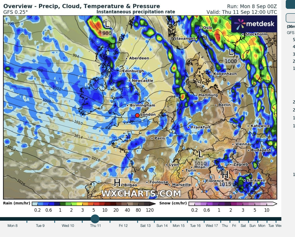
Netweather is forecasting a weekend washout
|WXCHARTS
But Britain’s weather is about to get a rattle as high pressure battles with unstable low pressure from the Atlantic.
A powerful jet stream will pull in cyclonic lows into mid-month hitting western regions with heavy rain.
Meteorologists are carefully watching a spinning system laden with heavy downpours threatening to strike today.
Met Office meteorologist Liam Eskick said: “We are keeping our eyes on an area towards the southwest on Tuesday with some heavy showers coming in from the south, and these could potentially be pretty blustery especially across the coastal regions of Devon, Cornwall and Wales.
“As we head through the rest of the week, things will start to turn a little bit more unsettled and there will be more showers to come with potentially more thunder.
“Towns and cities will stay in double figures, but in rural areas we will start to see temperatures drop into the mid-single figures.”
Southerly winds carrying a plume of 20C-plus humidity across southern Britain at the weekend will weaken through the coming days.
Temperatures in southern and eastern regions will hover in the low-20CS while elsewhere drops closer to average.
Rain will turn heavier through the week with a growing risk of thunder ahead of the weekend, experts warn.
Netweather’s Nick Finnis said: “Wednesday might finally see some rain reach eastern areas, as a new area of low pressure arrives to the northwest of Ireland and more active forcing along associated weather fronts spreading east reaches here.
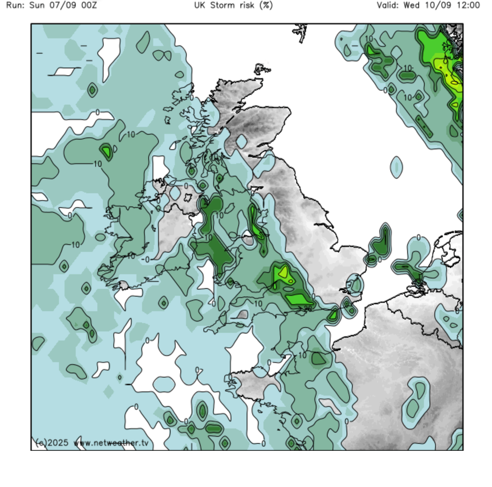
NetWeather is also warning that Britain's storm risk is increasing
|NETWEATHER
“Bands of showery rain, locally heavy with the odd rumble of thunder, look to spread eastwards across most parts through the day, after a dry and bright start.”
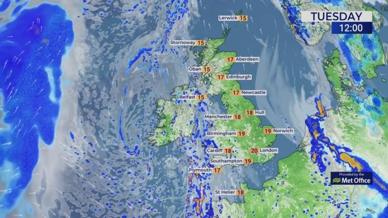
Met Office meteorologist Craig Snell added: “On Tuesday, temperatures could reach the low-20Cs in the east, but there will be cloud and rain across the west, where it will be a little bit cooler than of late.
“For most, there is lots of sunshine around although it is a different story towards Cornwall, with a band of cloud and rain moving in, and that will gradually spread eastwards as the day goes on.”