UK weather forecast: Temperatures to surge above 20C in just days as 'exceptionally warm' Mediterranean air descends over Britain
NetWeather's Ian Simpson says that high winds will force up air from the Mediterranean and send temperatures ratcheting upwards by the middle of the week
Don't Miss
Most Read
Temperatures are set to surge into the low 20s in just days as "exceptionally warm" air from the Mediterranean is pushed north towards the UK.
The weekend has seen temperatures in single figures and even dropping below zero overnight in some areas.
Frost descended across the country and the Scottish mountains even saw their first dusting of snow.
But in just a mater of days conditions are set to change.
 Temperatures will sure to the low 20s by the middle of next week | NETWEATHER
NetWeather's Ian Simpson says that high winds will force up air from the Mediterranean and send temperatures ratcheting upwards by the middle of the week.
He said: "Sunday looks set to be cool and sunny for most of us, but with cloud increasing in western areas during the afternoon and evening.
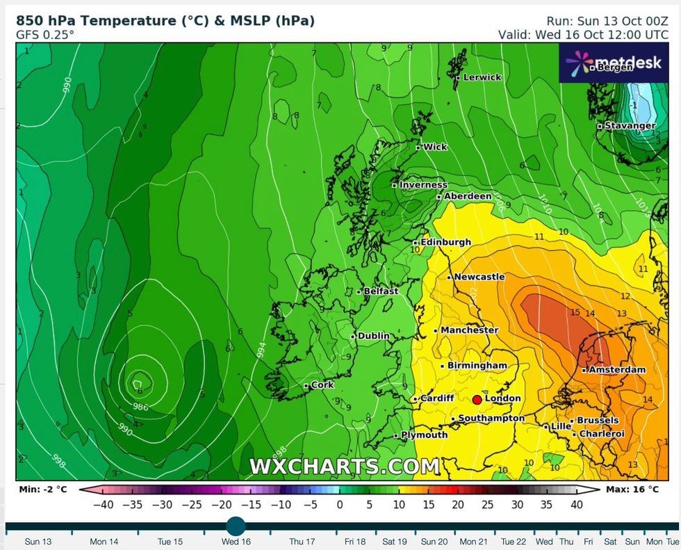
"However, a marked change of weather pattern is forecast to set in next week, as temperatures are set to increase substantially, reaching well above average values for the time of year, due to a period of mainly southerly winds, pulling air masses all the way up from the Mediterranean.
"The warmth will peak on Wednesday and Thursday with many areas, especially in southern and eastern England, forecast to reach the low 20s Celsius on one or two of the days, which is not record-breaking for the time of year, but somewhat above the mid-October long-term average.

Unseasonably warn temperatures are set to remain for some time
|WXCHARTS
"One or two of the nights has potential to be more exceptionally warm.
"There is potential for parts of England and Wales to see overnight minima of 14 to 16C overnight Wednesday/Thursday, which is close to what these regions would normally expect to see as a daytime maximum around mid-October."
Exacta Weather's James Madden is predicting the same, and anticipated the unseasonably warn temperatures to remain for some time.
He said: "From in and around Sunday and Monday, we will begin to see high pressure starting to rise across our shores to bathe us in some much warmer than average temperatures for the time of the year and October, and a more predominant theme of these high pressure rises could now take effect over the coming weeks and into late October.
"However, it might not be entirely straightforward as the jet stream looks to stay a little erratic at times, bringing some interspersed and potentially cool/colder days with unsettled weather at times during these high pressure rises."
On top of the warm temperatures, Simpson has also warned of thunderstorms in the week to come, forecasting: "After a quiet day tomorrow, the weather will turn more unsettled again, and there is potential for the southerly winds to bring some thunderstorms, particularly through Tuesday and Wednesday, mainly for southern Britain, especially south-west England.
"While thundery activity tends to decline somewhat as we head through the autumn, it is possible to get widespread thundery activity in October in this kind of setup, as was demonstrated several times during mid to late October 2022."
Despite the cold start to the month, in the end October as a whole is expected to finish as being warmer than average.


