


December’s deluge will climax this weekend in an eruption of thunder before Christmas is gripped by a bitter easterly wind.
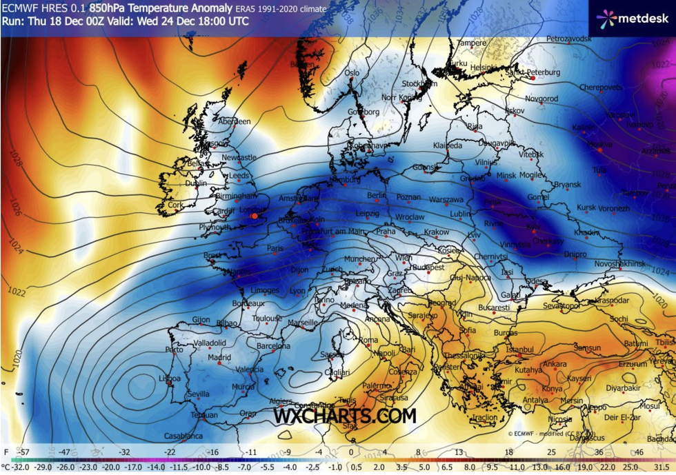
A dome of high pressure sliding in from Scandinavia will throw a reverse switch to pull in winds from Russia and eventually, Siberia.
As stormy weather patterns retreat, experts reveal the most likely festive outlook is dry, grey, and bitterly cold.
Despite the chilly poke from eastern Europe, a lack of snowfall across the Continent means little if chance of a White Christmas.
TRENDING
Stories
Videos
Your Say
Met Office meteorologist Alex Burkill said: “As we go through Christmas week, there is pretty high confidence that we will have higher pressure dominating with a Scandinavian high or high pressure just to the north of the UK, so the weather is set to turn quieter, drier and chillier.
“On Christmas Day, there is a 50 per cent chance of high pressure over northern parts of the UK, so it will be markedly dry compared to of late, but, we would be dragging in air from the east, and at this time of year an easterly wind is quite a chilly one.
“But, across eastern parts of Europe, there is less snow around than there would usually be at this time of year, so it probably won’t lead to as much of a drop in our temperatures.”
Dropping temperatures will signal a retreat of relentless wind and rain that has hammered the country so far this month.
Dropping temperatures will signal a retreat of relentless wind and rain
|WXCHARTS
The Atlantic will throw one last punch this weekend as a band of rain ignites a spate of thunderstorm.
As it moves in from the west, the narrow streak of downpours will force mild air skywards driving ‘line-convection’ eruptions, Burkill explained.
He said: “As we go into the weekend, there is a front out towards the west with a narrow band of rain with some line convection with rumbles of thunder and heavier bursts, and it is western areas where we are expecting to see the wet weather, and that is where we will have some strong winds.
“Looking at Christmas week, we are going to go from a more unsettled regime to high pressure being more dominant.
LATEST DEVELOPMENTS
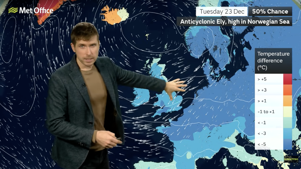
Alex Burkill warns of incoming easterly winds
|MET OFFICE
“Boxing day is s similar story with high pressure dominating, and we would continue with that easterly, and the longer it lasts more of that colder air could be catching, so the longer it lasts there is the potential that we could get some of our air from Siberia.”
Long-range experts agree this weekend will bring a turning point from wet and windy to calm and dry.
Stubborn high pressure wedged over the UK could spell the end of any more rainfall this year.
And falling temperatures could hold out into the start of 2026 as Britain shivers under a winter pressure dome.
Jim Dale, meteorologist for British Weather Services and co-author of ‘Surviving Extreme Weather’, said: “High pressure is likely to remain into the New Year with January looking colder than December so far.
“It will also be drier with the Atlantic losing its influence.”