


Britain’s countdown to Christmas faces a sledgehammer assault from the jet stream as mild weather gives way to Arctic gales, torrential rain and snow.
Temperatures in the mid-teens are about to tumble with disruption warnings for heavy rain likely this weekend. The U-turn will be triggered by the jet stream powering over the Atlantic to push in swirling currents of low pressure.
Coastal regions in the far north are braced for gusts of up to 75mph as plunging temperatures bring wintery showers.
Met Office meteorologist Alex Burkill said: “The jet stream is helping strengthen an area of low pressure pushing in from the Atlantic on Friday, and it is going to bring some very windy weather to northern parts. As low pressure drifts to the northeast, we will see the return of cold Arctic air with temperatures dropping again on Saturday and Sunday. On Friday, there are some strong gusty winds across northern and western Scotland, and we could see gusts of 75mph in some coastal spots, and the colder air could make more likely a few wintry showers across the Highlands of Scotland.”
TRENDING
Stories
Videos
Your Say
Wind and rain will hold out through the weekend and into Monday as Britons open their first Advent-calendar windows. As Yuletide celebrations get into swing, the jet stream will be working on Atlantic lows to douse a deluge over the fun.
Mr Burkill said: “An area of low pressure is developing, and this could get pretty deep bringing some wet and pretty windy weather on Saturday into Sunday, but there is some uncertainty. The Met Office model shows some strong gusts along the south coast, and along the eastern coast we could see gusts of around 50 to 60mph or a touch stronger, and this could cause some impacts.”
While there is little chance of this weekend seeing a named storm, the next would be Bram, Mr Burkill explained.
He said: “If we were to name this storm, although were not expecting to, we would be going for storm Bram, which is the next name on the UK storm list. As well as the strong winds, we need to be aware of some high rainfall totals, and there will be some more wet weather as we go through Sunday and through the two days there could be up to 50mm in a few places. With the colder air coming down from the north, there could be something wintry with some sleet and snow.”
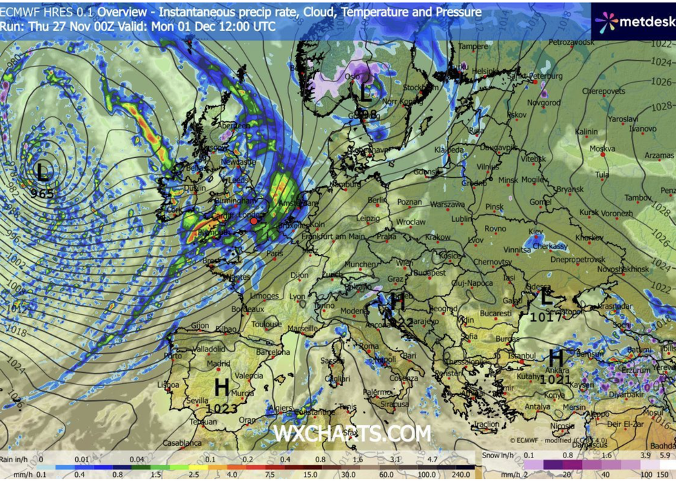
The Met Office has warned the jet stream is powering storms
|WXCHARTS
Long-range forecasters agree on a stormy run up to Christmas with any snow largely confined to the north. Although temperature will yo-yo between mild and freezing, a festive whiteout is growing ever unlikely.
Jim Dale, meteorologist for British Weather Services and co-author of Surviving Extreme Weather, said: “I would expect that the storm season is going to come back to life in December, and we could see a named storm by the end of the year. It is still early to be sure about snow at Christmas, but from recent patterns, it is more likely to get a milder, Atlantic-driven pattern, than snow as this usually comes in January or February. In general, November and December have almost been written off for widespread snow.”
Our Standards: The GB News Editorial Charter