


A fired-up jet stream powered by an Arctic mega freeze gripping America is about to give Britain’s weather its next pounding.
December’s arrival will be dogged by torrential rain, gales, hail, thunder and in parts, the risk of snow.
Relentless stormy weather patterns will be swept in by an unusually feisty jet stream hurtling across the Atlantic.
Winds at the core of the jet stream will nudge 200mph, touching the top end of a 110mph to 200mph norm.
TRENDING
Stories
Videos
Your Say
Met Office meteorologist Annie Shuttleworth said: “We have a powerful jet stream through this week that will drive areas of low pressure to the northwest of the UK.
“There is a strong temperature contrast across the northern parts of America, and very cold air is driving the jet stream which will bring some uncertainty to the forecast.
“Instead of persistent rain, we expect it to be more showery with showers more frequent across western areas, and some of these showers could bring the risk of hail and thunder.
“There will be pretty brisk winds across northwestern Scotland, and the risk of gale-force winds, so for now it is going to bring a very unsettled few days.”
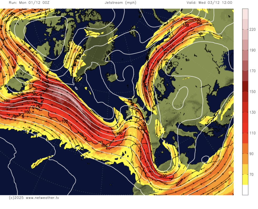
Relentless stormy weather patterns will be swept in
|NETWEATHER
Persistent weather fronts dragged in on cyclonic low-pressure centres threaten at least another week of rain.
Western regions in the firing line of the deluge will come under a looming threat of flood disruption.
Although the heaviest downpours will ease, persistent showers will keep nudging ground-water levels.
Shuttleworth said: “There is more rain to come this week, although we have had the worst of it already.
LATEST DEVELOPMENTS
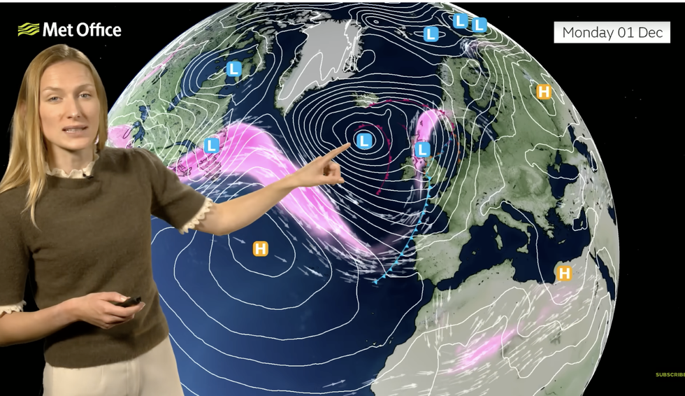
Annie Shuttleworth warns cold air over US will fire the jet
|MET OFFICE
“The next front moves through on Thursday, and the rain could linger across southeastern areas.
“Rainfall totals tot up during the week, and most areas will see at least some rain with particularly the west seeing the highest totals, and because we have saturated ground, we could see some further travel disruption and flooding.”
Jet stream winds carrying storms towards the UK are being powered by cold weather hitting America.
Cold northerly air meeting milder air to the south of the country is driving the jet, which draws its strength from temperature contrasts.
While the US is gripped by the first winter storm of the season, the jet’s arrival to the UK spells a more unsettled period.
Jim Dale, meteorologist for British Weather Services and co-author of ‘Surviving Extreme Weather’, said: “Another front is coming in at the end of the week, and this is associated with low pressure pulled in and strengthened on the jet stream.
“Through the weekend, yet more weather fronts carrying rain will dominate the UK’s weather, which means we are looking at a lot of rain throughout the next week.
“Western regions will see the heaviest downpours, and here there will be a mounting risk of floods.”
Met Office meteorologist Alex Deakin added: “We will continue to see showers in western Scotland on Wednesday, and these showers are coming into areas that are very soggy indeed.
“There is another band of rain starting to move in overnight Wednesday and into Thursday.”