


The Met Office has issued seven urgent weather warnings as the Met Office has named the next storm.
An amber warning for rain has been issued in south west England stretching from St Austell along the coast to Swanage from 5pm today to 9am tomorrow as Storm Chandra is set to batter the UK on Tuesday.
The storm is forecast to bring strong winds, heavy rain and snow across much of the UK through most of tomorrow, with yellow warnings in place across most of Wales and South West England.
Most of Northern Ireland has been covered with an amber warning for wind from 5am to 9pm on Tuesday.
Forecasters say flooding and travel disruption are likely in some places and there will also be some significant snow across higher ground in some northern parts of England and some of Scotland.
Several weather warnings have been issued, including amber warnings for south-west England and the eastern coast of Northern Ireland for rain and wind respectively.
Less severe yellow warnings are in place for all of Northern Ireland and a more extensive area of south west England, as well as parts of northern England and Scotland.
Great Western Railway (GWR) said the train line between between Par and Newquay was closed due to flooding on Monday.

Storms are set to hit much of the UK this week
|GETTY
Disruption is currently expected until the end of the day and rail replacement transport would be in place between St Austell and Newquay.
Rail replacement transport is in place and coaches departing from Liskeard and Looe at train times, GWR said.
Further north, as precipitation encounters colder air it will fall as hill snow on the northern edge of the system.
Yellow warnings for snow have been issued for Scotland and northern England where 2-5cm could fall widely within the warning areas and as much as 10-20cm could accumulate at elevations over 500 metres.
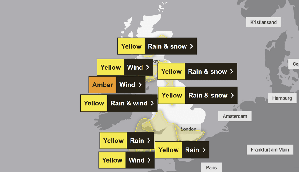
The weather alerts in place across the UK
|MET OFFICE
LATEST DEVELOPMENTS
Met Office Chief Forecaster, Paul Gundersen, said: “Storm Chandra will bring a range of hazards to the UK through Monday night and Tuesday.
"Initially strong winds will impact the Isles of Scilly, western Cornwall and southwest Wales which are still vulnerable after Storm Goretti, gusts of 70 to 80mph are possible here.
"Heavy rain is an additional hazard as it falls on saturated ground in Dorset and southern parts of Devon, Somerset and Cornwall.
"As Chandra interacts with colder air further north snow becomes a hazard, with 10-20cm of snow possibly accumulating over higher ground in the Pennines, southern Scotland and the Highlands.
"With a complex spell of weather, its important people stay up to date with the forecast and any warnings in your area."
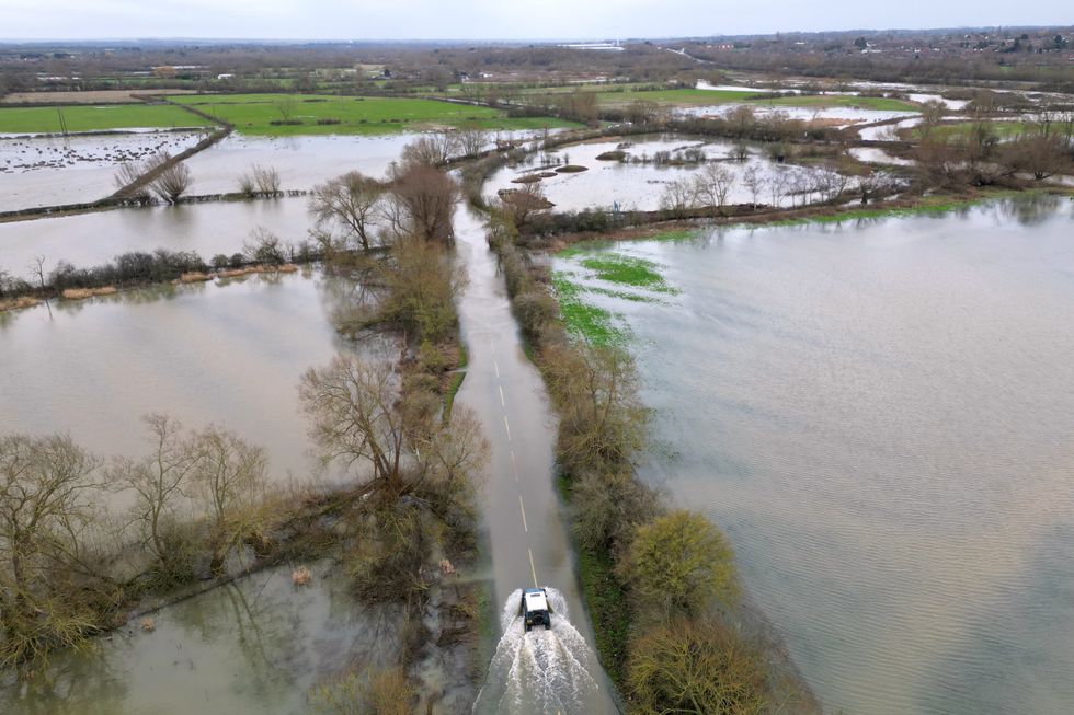
Flooding impacted much of the south west England
|PA
Storm Chandra is the next storm on the western Europe storm naming group list shared between the UK, Ireland and Netherlands.
Other recent storms, such as Storm Goretti, have been named by other storm naming centres.
According to forecasters, the rest of the week continues to be unsettled with further spells of wet and windy weather.
Wednesday is set to bring the best day of weather for most, with dry and at times bright conditions in the east, however rain and cloud persists in the west.