


Thousands of households living in specific parts of the UK could be in line for extra energy bill support thanks to the Department for Work and Pensions' (DWP) Cold Weather Payment scheme. The Government department has published a list of the postcodes that qualify for this year's payment.
The country has been smothered in snow over the past week as temperatures have dropped to as low as minus 10.9 degrees in certain regions, such as Cumbria, with Storm Goretti forecast to exacerbate Britain's weather woes.
The DWP's Cold Weather Payment is one example of the energy bill support schemes available to financially vulnerable individuals during periods of sub-zero temperatures, offering £25 off the cost of heating someone's home.
Britons are only eligible for this support if they claim a qualifying DWP benefit, with £25 up for grabs for every seven days of extremely cold weather between November 1, 2025, and March 31, 2026.
Cold Weather Payments are being paid out to households living in hundreds of postcodes
|GETTY
Money is paid into the bank or building society account, from which someone receives their DWP benefits within 14 days of the initial cold spell, and will be paid alongside their payments or pension.
Anyone who believes they have missed out on a Cold Weather Payment should contact either the DWP directly or visit their local Jobcentre to see why it has not been paid.
Universal Credit claimants can use their online journal or call the DWP payment helpline to report such cases. Benefit claimants can also use the DWP's postcode checker to see if their local area qualifies.
Here is a full list of the DWP benefits someone needs to receive at least one of to qualify for a Cold Weather Payment:
- Pension Credit
- Income support
- Income-based jobseeker’s allowance (JSA)
- Income-related employment and support allowance (ESA)
- Universal Credit
- Support for mortgage interest (SMI).
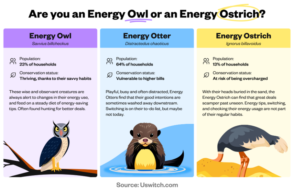 "Energy Owls" actively manage their energy usage, check tariffs, and track their bills. | Uswitch
Here is a full list of the latest qualifying postcodes for Cold Weather Payments:
Cumbria (Lake District and Eden areas)
- CA9: Alston
- CA10: Penrith
- CA11: Penrith
- CA12: Keswick
- CA16: Appleby-in-Westmorland
- CA17: Kirkby Stephen
- LA8: Kendal
- LA9: Kendal
- LA10: Sedbergh
- LA21: Grange-over-Sands
- LA22: Ambleside
- LA23: Windermere.
Northumberland
- NE19: Wooler
- NE47: Hexham
- NE48: Bardon Mill
- NE49: Haltwhistle.
Scottish Borders (Dumfries and Galloway)
- DG14: Annan
- TD9: Hawick
LATEST DEVELOPMENTS
Here is a full list of the qualifying postcodes that were triggered earlier this week:
North Yorkshire / Craven
- BD23 – Skipton and surrounding villages
- BD24 – Settle area
- DL8 – Leyburn / Wensleydale
- DL11 – Reeth / Swaledale.
County Durham & Darlington area
- DH1 – Durham
- DH6 – Bowburn / Coxhoe area
- DH7 – Sacriston / Lanchester area
- DH8 – Consett
- DH9 – Stanley
- DL4 – Shildon
- DL5 – Newton Aycliffe
- DL12 – Barnard Castle
- DL13 – Stanhope / upper Weardale
- DL14 – Bishop Auckland
- DL15 – Crook
- DL16 – Spennymoor
- DL17 – Ferryhill / Chilton
- TS21 – Sedgefield / west of Stockton
- TS28 – Wingate
- TS29 – Trimdon Station / Deaf Hill.
Cumbria / Brecon & mid‑Wales fringe
- LD3 – Brecon and surrounding area (Powys).
Cambridgeshire (Cambridge, Ely, South Cambs, East Cambs)
- CB1, CB2, CB3, CB4, CB5 – Cambridge city districts
- CB6, CB7 – Ely and nearby villages
- CB10, CB11 – Saffron Walden area (Essex but in CB area)
- CB21, CB22, CB23, CB24, CB25 – South and east Cambridgeshire villages (Linton, Sawston, Cambourne, Cottenham, Bottisham etc.)
- PE19 – St Neots (Hunts / Cambridge).
Essex (Chelmsford, Braintree, Maldon, Uttlesford, Harlow)
- CM1, CM2 – Chelmsford
- CM3 – Rural east of Chelmsford / South Woodham Ferrers fringe
- CM4 – Ingatestone
- CM5 – Ongar
- CM6 – Great Dunmow (Uttlesford)
- CM7, CM77 – Braintree districts
- CM8 – Witham
- CM9 – Maldon / Heybridge
- CM11, CM12 – Billericay
- CM13, CM14, CM15 – Brentwood
- CM16 – Epping
- CM17, CM18, CM19, CM20 – Harlow
- CM21 – Sawbridgeworth
- CM22, CM23, CM24 – Takeley / Bishop’s Stortford / Stansted Mountfitchet
- CO9 – Halstead area
- RM4 – Rural fringe: Havering‑atte‑Bower / Stapleford Abbotts / Abridge (Essex–London border).
 Very cold weather has sparked Cold Weather Payment triggers in parts of the UK | GETTY
Hertfordshire & Bedfordshire (SG + parts of CM/MK)
- SG5 – Hitchin and surrounding villages (Herts/Beds)
- SG6 – Letchworth Garden City
- SG7 – Baldock
- SG8 – Royston and surrounding villages
- SG9 – Buntingford
- SG10, SG11 – Much Hadham / Standon / Puckeridge area
- SG15 – Arlesey
- SG16 – Henlow
- SG17 – Shefford
- SG18 – Biggleswade
- SG19 – Sandy and nearby villages
- MK40, MK41, MK42 – Bedford
- MK43 – Marston Moretaine / Cranfield area
- MK44 – North‑east Bedford rural
- MK45 – Ampthill / Flitwick
- MK46 – Olney (Bucks/Beds/Northants border.
Milton Keynes & north Buckinghamshire
- MK1, MK2, MK3 – Bletchley districts
- MK4, MK5, MK6, MK7, MK8, MK9, MK10, MK11, MK12, MK13, MK14, MK15 – Milton Keynes urban districts
- MK16 – Newport Pagnell
- MK17 – Woburn Sands and nearby villages
- MK18 – Buckingham and villages
- MK19 – Hanslope / rural north‑west of MK.
Northamptonshire
- NN1, NN2, NN3, NN4, NN5 – Northampton urban area
- NN6, NN7 – Rural north and south‑west of Northampton
- NN8 – Wellingborough
- NN9 – Raunds / Irthlingborough
- NN10 – Rushden
- NN11 – Daventry
- NN12 – Towcester
- NN13 – Brackley
- NN29 – Wollaston and nearby villages.
Norfolk (Norwich, King’s Lynn, Breckland, North Norfolk, Great Yarmouth, Waveney)
- NR1, NR2, NR3, NR4, NR5, NR6, NR7 – Norwich city and suburbs
- NR8, NR9, NR10 – Taverham / Drayton / Hethersett / Coltishall belts
- NR11, NR12, NR13 – North‑east Norfolk / Broads villages
- NR14, NR15 – Poringland / Loddon / Long Stratton
- NR16, NR17, NR18 – East Harling / Attleborough / Wymondham area
- NR19, NR20 – Dereham and rural surrounds
- NR21 – Fakenham
- NR22, NR23 – Walsingham / Wells‑next‑the‑Sea area
- NR24, NR25 – Melton Constable / Holt / Blakeney
- NR26 – Sheringham
- NR27 – Cromer
- NR28 – North Walsham
- NR29 – Martham / north of Great Yarmouth
- NR30, NR31 – Great Yarmouth / Gorleston
- NR32, NR33 – Lowestoft (Suffolk)
- NR34 – Beccles (Suffolk/Norfolk border)
- NR35 – Bungay (Suffolk/Norfolk border)
- PE30, PE31, PE32, PE33, PE34, PE35, PE36, PE37, PE38 – King’s Lynn, Hunstanton, Swaffham, Downham Market and surrounding Norfolk villages.
Suffolk / Norfolk fringe (Thetford, Brandon, Mildenhall)
- IP24 – Thetford (Breckland, Norfolk, close to Suffolk border)
- IP25 – Watton (Breckland)
- IP26 – Mundford and villages
- IP27 – Brandon (Suffolk/Norfolk border)
- IP28 – Mildenhall / Lakenheath (Suffolk)
- PE12, PE13, PE14 – Long Sutton / Holbeach / Wisbech and Fens (Lincs/Cambs/Norfolk fringes).
North‑East England (Northumberland / Tyne Valley)
- NE18 – Stamfordham area (Northumberland)
- NE20 – Ponteland
- NE44 – Riding Mill
- NE45 – Corbridge
- NE46 – Hexham.
South Wales – Cardiff, Valleys, Gwent
- CF37, CF38 – Pontypridd / Tonteg / Llantwit Fardre (Rhondda Cynon Taf)
- CF39, CF40, CF41, CF42, CF43 – Porth, Tonypandy, Pentre, Treorchy, Ferndale (Rhondda Cynon Taf)
- CF44, CF45 – Aberdare / Mountain Ash (Rhondda Cynon Taf)
- CF46 – Treharris (Merthyr Tydfil / Caerphilly border)
- CF47, CF48 – Merthyr Tydfil districts
- CF81, CF82 – Bargoed / Ystrad Mynach (Caerphilly)
- CF83 – Caerphilly and Bedwas area
- NP4 – Pontypool (Torfaen)
- NP11 – Risca / Abercarn (Caerphilly)
- NP12 – Blackwood (Caerphilly)
- NP13 – Abertillery (Blaenau Gwent)
- NP22 – Tredegar (Blaenau Gwent)
- NP23 – Ebbw Vale (Blaenau Gwent)
- NP24 – New Tredegar (Caerphilly/Blaenau Gwent)
- NP44 – Cwmbran (Torfaen).