US weather: ‘Super El Nino’ to bring more flooding and ‘winter of discontent’

Bands of heavy rain sweep across parts of the US
|WX charts

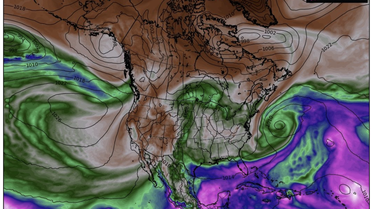
The ‘Super El Nino’ event is feared to be undergoing an unusual strengthening
Don't Miss
Most Read
Latest
America's flood woes could be about to worsen with a ‘super El Nino’ tropical weather event threatening a deluged ‘winter of discontent’.
Southern states are in the firing line for persistent and heavy downpours through the coming months, according to some long-range outlooks.
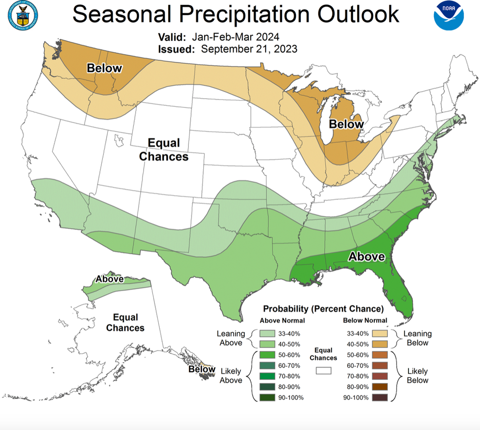
The National Ocean and Atmospheric Administration’s (NOAA) Climate Prediction Centre warned of a 30- to 50-per cent chance of above average rainfall across the southern United States this winter.
El Nino, caused by warming of ocean temperatures along the west coast of South America, was confirmed earlier this year.
WATCH NOW: UK weather outlook 03/10/2023
The phenomenon, which can trigger changes in weather patterns around the globe, is feared to be undergoing an unusual strengthening.
Jim Dale, US weather correspondent and senior meteorologist for British Weather Services, said: “Wetter weather across the southern states would be in line with an El Nino strengthening, and so we could be looking at a winter of discontent.
“This would bring the continued risk of much wetter weather and flooding in this part of the States.
“Also in line with El Nino, it is likely to be milder across this region.”
In the United States, El Nino can cause wetter conditions to the southwest, cooler and drier conditions to the east and warmer northern temperatures.
An El Nino winter would push the sub-tropical jet stream downwards channelling a belt of storms across southern states.
US LATEST:

Wetter weather predicted by NOAA
|NOAA
Mr Dale said: “We are now starting to see the global effect of El Nino, and it is reaching into the United States.
“It is also linked to drier conditions across northern states, which is something that we would expect to see as we get into winter.
“If El Nino strengthens in the way that the NOAA suggests, then the effects on the jet stream and its movement across the States will contribute to this sort of weather pattern.”
CNN meteorologist Derek Van Dam said: “You can expect more winter storms along the east coast.
“This is the typical weather pattern that El Nino drives during the core of the winter months.
“Take note of an amplified storm track that is the southern Polar jet stream which is running across the southern tier of the US.
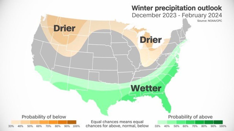
“According to the Climate Prediction Centre, they are calling for above normal precipitation.”

CNN meteorologist Derek Van Dam said: 'You can expect more winter storms along the east coast'
|NOAA/CPC
The Weather Channel’s Danielle Banks added: “The National Centre for Atmospheric Research says we could be in store for a super El Nino.
“A stronger El Nino could mean stronger impacts, but El Nino is not the only factor that helps drive the weather.”
Sea-surface temperatures across the Equatorial Pacific were above average in August as El Nino developed, according to the NOAA.
Latest forecast models predict El Nino will persist through the northern hemisphere winter, it said.
The National Centre for Atmospheric Research warned this winter could bring one of the strongest on record.
A spokesman said: “Current El Niño conditions are likely to develop into one of the strongest events on record — comparable to the major El Niño of 1997-98.
“El Niño events are characterized by warmer-than-average temperatures in the Tropical Pacific Ocean.
“The phenomenon, which usually peaks in December, can have a significant impact on weather patterns across the country, causing the northern US and Canada to become warmer and drier than usual while the southern US becomes wetter.”
It comes after torrential downpours and flash flooding across New York at the end of last week triggered a state of emergency.
The deluge was the result of Tropical Storm Ophelia which dumped inches of rain and whipped up strong winds as it lashed the Atlantic coast.


