


An autumnal chill will descend on Britain as the jet stream splits to smother the country with a sunless cloud dome.
Temperatures in parts will plummet to low single figures overnight with highs elsewhere nudging the mid- to high teens.
Bracing conditions will be driven by high pressure, usually the weclomer of summer sunshine, as it shifts north.
Forming a dome over the country, it will trap cloud as a cold front sweeps in from the north.
Met Office meteorologist Aidan McGivern said: “High pressure is going to return this week, but it is not going to bring a heatwave because it is located to the north of Scotland acting like a boulder in a stream, redirecting the jet stream, with one branch pushing well to the north into the Arctic circle and another pushing to the south.
“It is going to be bringing cooler air from the east and the northeast along with a lot of cloud.
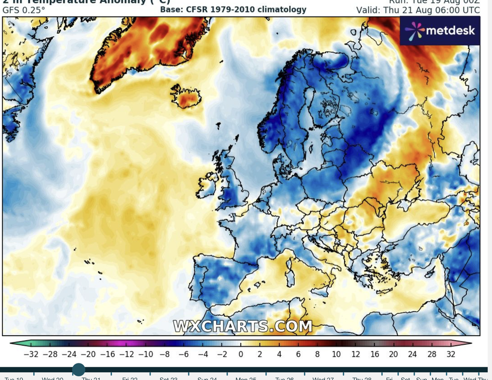
WXCHARTS expect temperatures to dip in the coming weeks
|WXCHARTS
“It is going to get cooler through the week ahead because of a cold front moving south, and this will nudge the low pressure further south so showers will tend to disappear, and high pressure will build from the north more widely.”
After weeks of warm weather and sleep-depriving tropical nights, Britons may need to get their blankets out.
Overnight temperatures could dip to 4C across northern parts with the south shivering around 10C.
A burst of sunshine at the end of the week could nudge thermometers back into the 20Cs, but nowhere close to the recent heatwave highs.
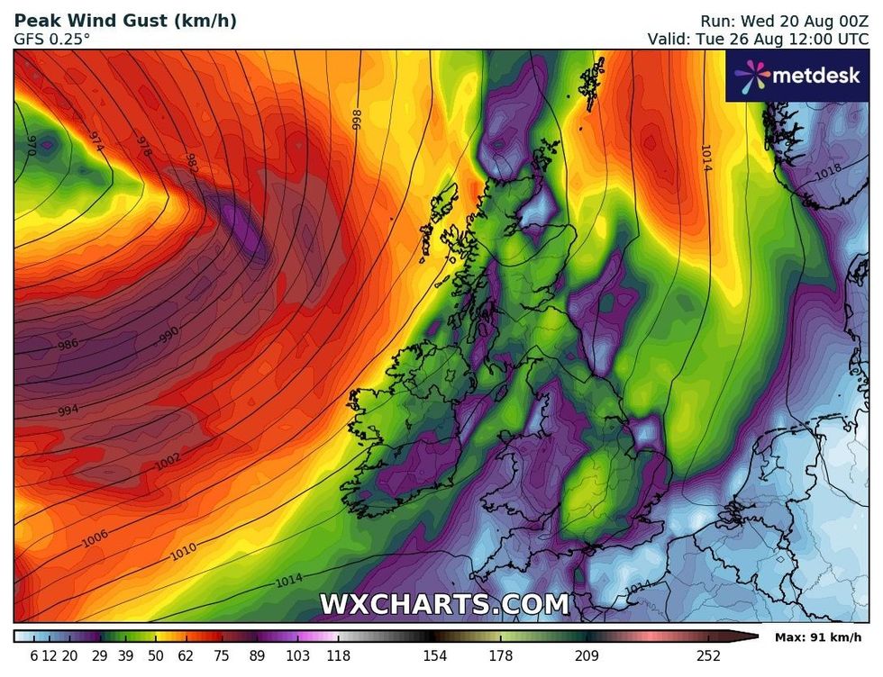
Peak wind gusts as will take hold on August 26
|WXCHARTS
McGivern said: “ On Thursday, most places will be dry, and although we have high pressure and sunshine, it is going to be cool for many, certainly compared to a lot of the hot spells we have experienced.
“Thursday night is going to be a colder night compared to previous nights, and we start the day on Friday with temperatures in urban places at 10C or 11C.
“But in the countryside, we could see mid- to high-single figures and in sheltered spots and with temperatures dipping into low single figures, it will be quite chilly in some places.
“On Friday, it will warm up through the day and will be pleasant enough with temperatures up to 23C.”
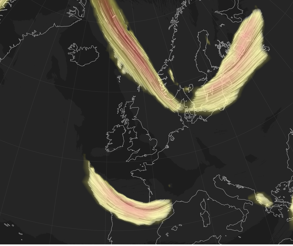
The jet streams will pincher Britain from both angles
|WXCHARTS
Miserable temperatures will dig down until the Bank Holiday when the mercury could head upwards.
The remains of Hurricane Erin, currently churning Caribbean waters at speeds of 135mph will take a U-turn and head towards Britain.
Although the hurricane will have perished over cool waters of the North Atlantic, its remnants could shake up the weather.
If they travel southwards, they will bring wind and rain, but a northerly track will bring a plume of warmth from the south.
Jim Dale, meteorologist for British Weather Services and social commentator, said: “The remains of Erin are likely to head north, over the tip of Scotland, and this could bring warmer air up from the Continent.
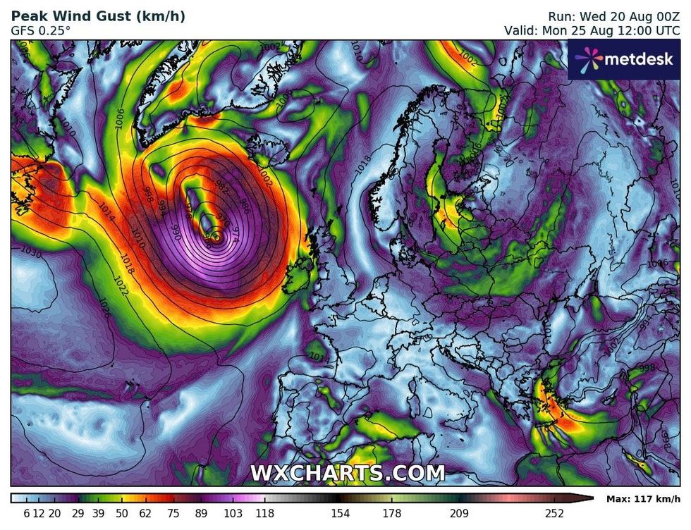
A wider image of the peak wind gust taking hold on August 25
|WXCHARTS
“It means that the end of the month could see temperatures back into the high-20Cs in places.
“It all depends, though on its effect on high pressure, and if high pressure flattens under the effect of Erin, then instead of the heat, we would get more in the way of rain.”
Meteorologists are closely watching the path of the storm and its potential impact on the Bank Holiday.
McGivern said: “There is low pressure over the Atlantic which could fringe upon western parts of the UK during the second half of the Bank Holiday to bring some showers.
“But this will potentially become subsumed by a second low, Hurricane Erin, a major hurricane which deepened into a Category-five monster, as it transitions into a mid-latitude low and gets picked up by the jet stream.
“Most models take it to the northwest of Scotland next Tuesday or Wednesday, so there is a lot to be determined between now and then.”