


A brief lull in sultry weather will erupt into another 30C-plus fire blast as a Bermudan heat dome slides back over Britain.
Thermometers will once again rocket this weekend sizzling the last fortnight of summer in blue skies and baking sunshine.
The Azores High, a huge high-pressure dome acting as a greenhouse, will build back across the UK triggering heatwave number five.
**ARE YOU READING THIS ON OUR APP? DOWNLOAD NOW FOR THE BEST GB NEWS EXPERIENCE**

A brief lull in sultry weather will erupt into another 30C-plus fire blast as a Bermudan heat dome slides back over Britain
|WXCHARTS/ NETWEATHER
Also known as the "Bermuda High" it threatens to pressure cook swathes of the country through the middle of August.
Jim Dale, meteorologist for British Weather Services, said: “After a brief drop in temperatures, the heat will return at the weekend as high pressure moves back to dominate the weather.
“We could see temperatures rise into the mid-30Cs, and if this lasts for three or more days, then we are looking at the fifth heatwave of summer.
“Southern regions will see the highest temperatures, and the greatest risk of any unsettled weather will be across the north.”
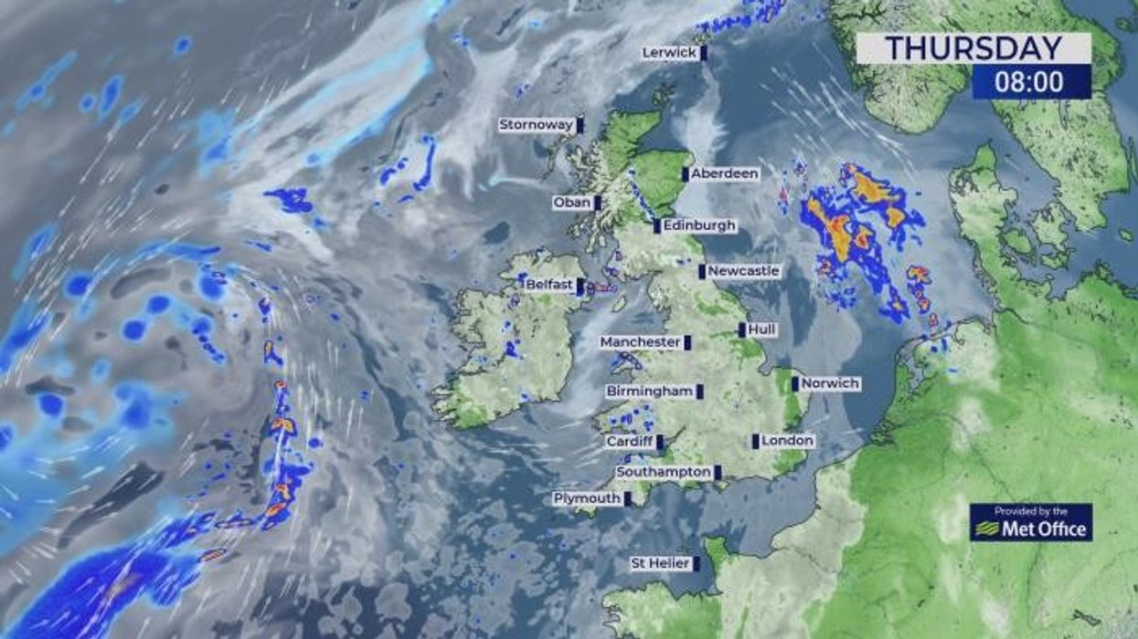
As heat and humidity build while cooler air briefly arrives to the north, the skies will erupt into violent thunderstorms.
Torrential downpours will cover swathes of the country while lightning strikes and gusty winds threaten weekend travel plans.
Dale said: “There is a lot of energy in the atmosphere, and with hot and humid air hitting colder air, there is the risk of some hefty thunderstorms.
“Although these are difficult to predict, where they do occur there could be disruption.”
Southern and central Britain will stay in the high-20Cs or above through the rest of the week while cooler winds hit the north.
High pressure will return on Friday nudging up temperatures, although showers will scatter around the edges of the dome.
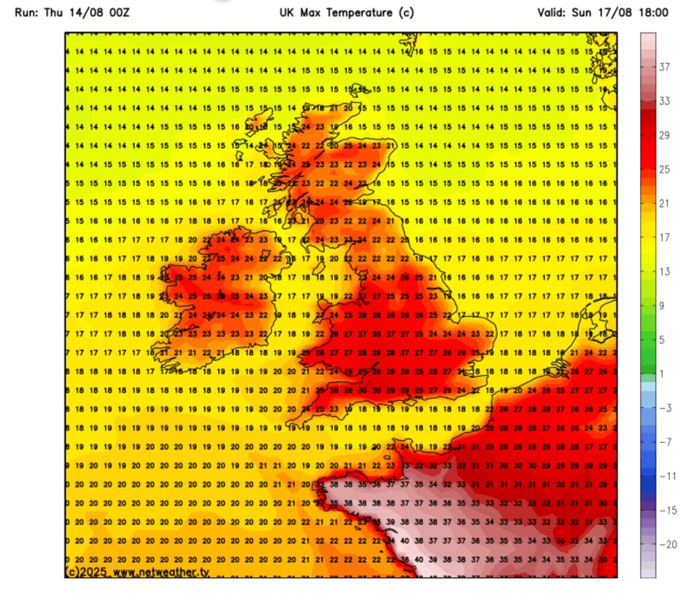
The Azores High, a huge high-pressure dome acting as a greenhouse, will build back across the UK triggering heatwave number five
|NETWEATHER
Met Office meteorologist Alex Burkill said: “On Friday, we are starting to get high pressure returning, building and becoming more dominant.
“There is a good deal of fine weather and a bit more sunshine on offer and temperatures are going to be a degree or so higher in southern parts on Thursday, so a greater chance of getting back into the low-30Cs.
“We are sticking with high pressure as we go into the weekend, but around the edges of the high we will see something more changeable.
“It is towards the south and the southwest into Saturday that there is the potential for some showery bursts, and these could feed up the western parts of the UK through the weekend.”
As temperatures head back up, tropical heat will destabilise the atmosphere triggering violent thunderstorms.
A Met Office spokesman said: “Temperatures on Thursday will likely reach 29C to 30C, especially in the far east of England, and staying closer to average in the west.
“A north-south split is likely on Friday, with cloudier conditions and some patchy rain or drizzle in parts of the north, but plenty of fine and sunny weather in the south. “Temperatures in the sunshine are likely to peak at 30C, and there is the possibility of a few showers or thunderstorms in the southwest later on Friday and into the weekend.”