


Britain is bracing for its fourth heatwave of the summer, with meteorologists predicting temperatures could soar to 33C on Tuesday.
The UK Health Security Agency has issued yellow heat health warnings covering most of England from Monday through Wednesday in anticipation of the blistering heatwave.
Only the north-east and north-west regions of Britain will be exempt from the alerts.
**ARE YOU READING THIS ON OUR APP? DOWNLOAD NOW FOR THE BEST GB NEWS EXPERIENCE**
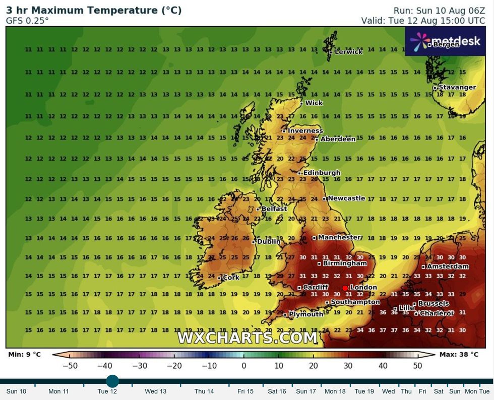
Britain is bracing for its fourth heatwave of the summer, with meteorologists predicting temperatures could soar to 33C on Tuesday
|WXCHARTS
The conditions will continue for at least three consecutive days, meeting the official criteria for a heatwave declaration.
Areas including east Wales, the Midlands, and south-eastern England are expected to experience the most intense heat.
Met Office Deputy Chief Meteorologist Tom Crabtree said: "Warmth is the focus in the forecast in the first half of this week, with temperatures likely to peak on Tuesday around the mid-30s, but remaining above average in the second half of the week, particularly further to the southeast.
"The exception to the widely warm conditions will be northwest Scotland on Monday, where showers will be more frequent.
"Warmth will develop there from Tuesday with temperatures peaking in the mid to high 20s."
A combination of high pressure moving across southern Britain and low pressure in the Atlantic, which contains what remains of Tropical Storm Dexter, will pull warm air northward from the south.
Monday will see temperatures climbing into the mid to upper twenties across much of England and Wales.
LATEST DEVELOPMENTS:
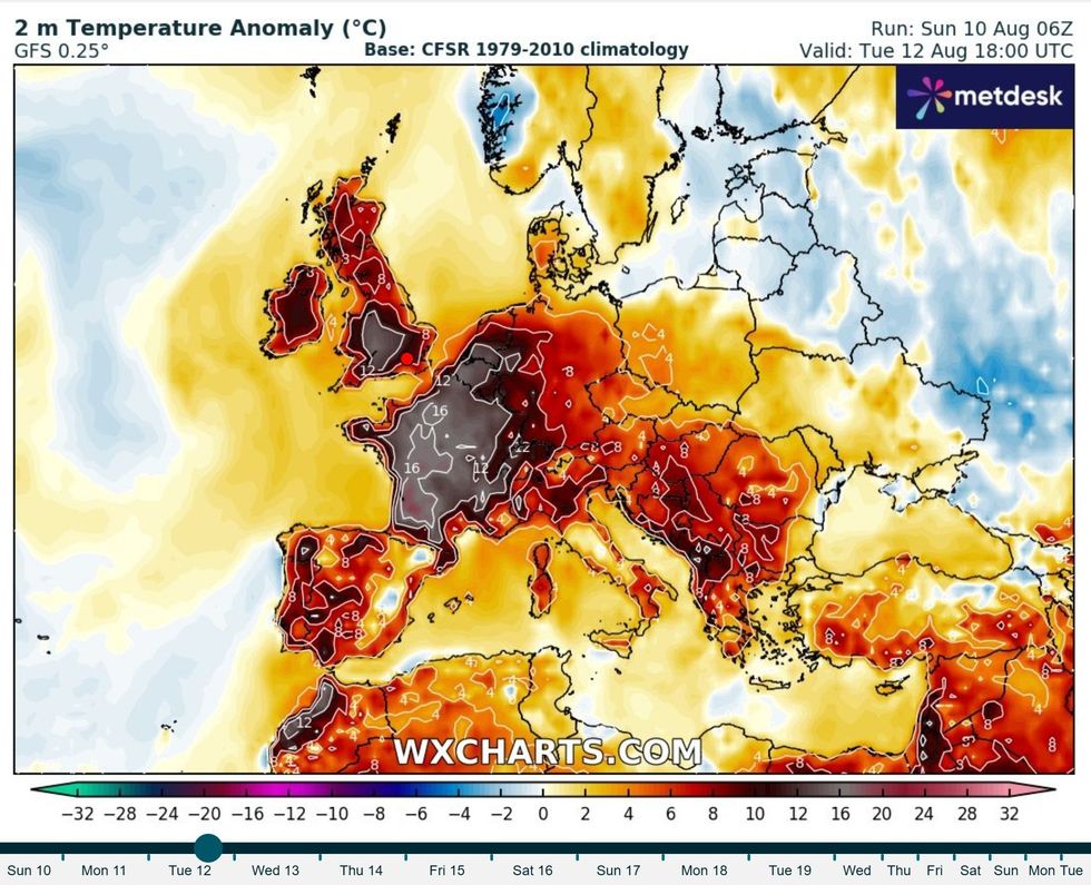
WX Charts map shows expected temperature anomaly on Tuesday, August 12
|WX CHARTS
Some areas in London are forecast to exceed 30C.
The hottest conditions are anticipated on Tuesday, when most of England and Wales will experience temperatures in the upper twenties.
East Wales, the Midlands, East Anglia and south-eastern England could see widespread temperatures above 30C, with some south Midlands locations potentially reaching 33C during Tuesday afternoon.
England and Wales will enjoy the finest sunshine, though isolated thunderstorms could develop in some areas.
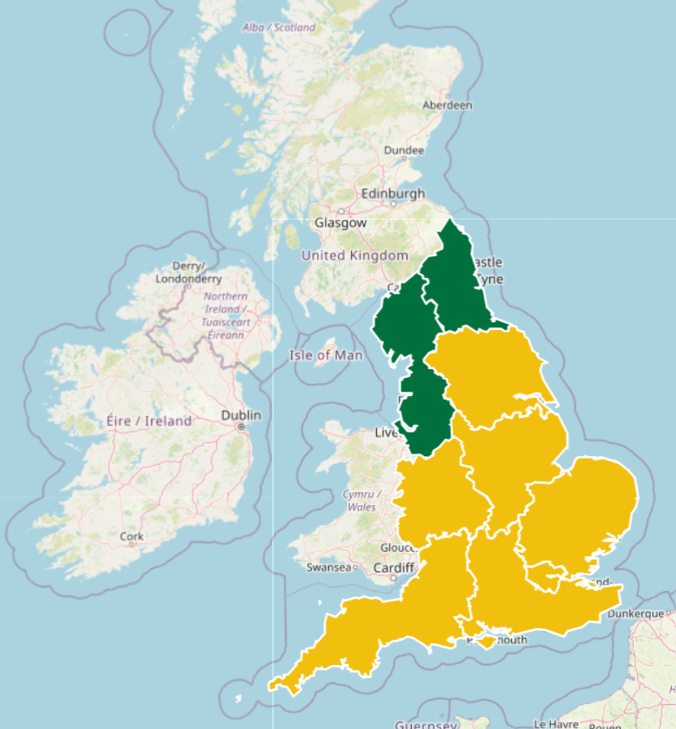
The UK Health Security Agency has issued yellow heat health warnings covering most of England from Monday through Wednesday
|GOV.UK
Heavy downpours may form and drift northward across certain regions as the week progresses.
Northern parts of the UK face different conditions entirely, with Scotland and Northern Ireland preparing for intermittent rainfall, particularly on Monday, missing the extreme heat affecting southern regions.
Despite the wet weather, these northern areas could still record highs between 23C and 25C.
These temperatures remain notably above seasonal averages, running approximately 4C to 7C warmer than typical for this time of year.
Crabtree continued: "Outbreaks of rain, some of which could be thundery, are possible in southern and western areas for a time on Monday evening spreading north and east through the night, though this will be fairly hit-and-miss and for many the weather will be a dry and warm day.
"While there’s a fair degree of uncertainty at this range, the main signal for more frequent thundery showers arrives from the south late on Wednesday and into Thursday.
"The risk of showers spreads north and west on Thursday, potentially bringing some fairly wet weather to Scotland, northwest England and parts of Wales through the day."