


Britain will face the glare of the near 100-mile-wide eye of a tropical hurricane as Atlantic ‘disturbances’ unleash gales, downpours and plunging temperatures.
Hurricane Nigel will this weekend be the third Atlantic storm to give the UK weather a shake-up, its remnants arriving in the wake of ex-Lee and ex-Margot.
Another cluster of tropical storms brewing around the US east coast threaten to hitch a ride on the jet stream next week and head across the pond.
Britain’s weather could be fraught with winds, rain and yo-yoing temperatures through the end of the month, experts warn.
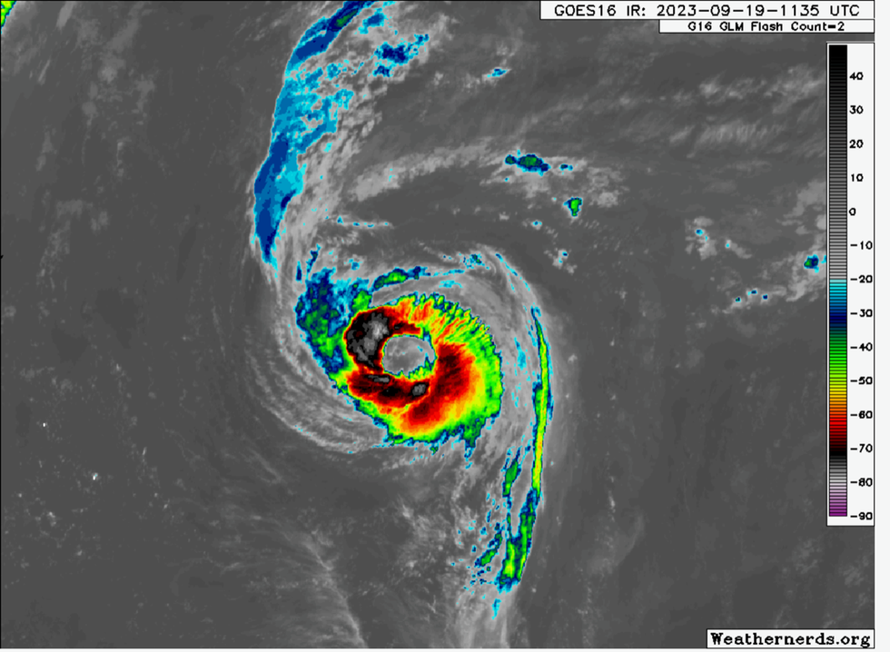
The massive eye of Hurricane Nigel
|weathernerds.org
Jim Dale, meteorologist for British Weather Services, said: “The UK is getting a lot of wet and windy weather as patterns are affected by the remnants of Hurricanes Lee and Margot.
“Nigel is now going to move towards the northwest of the UK, towards the coast of Scotland, and there may be a bit more to it than we saw with Lee and Margot.
However, there is a possibility of high pressure building after Nigel has moved off, and this would bring clearer weather.”
Hurricane Nigel is currently heading north-eastwards at around 85mph from the coast of America.
The storm is unusual in sporting a colossal, churning eye spanning 90 miles compared to between the norm of 20 to 40 miles.
Chris Dolce, senior digital meteorologist for The Weather Channel, said: “Hurricane Nigel displayed a massive eye on satellite Tuesday morning, measuring about 90 miles wide.
“Most eyes average about 20 to 40 miles across, but they can be as small as a few miles or as large as 120 miles, according to NOAA’s Hurricane Research Division.
“In 2005, Wilma was an example of a hurricane on the opposite side of the spectrum from Nigel.
MORE WEATHER
UK weather: Exact date when Britain is set for sizzling heat plume following weekend washout
"It had a pinhole eye just 2.3 miles wide when it was a Category-5 in the Caribbean.”
Nigel will join with a second cyclonic system on its journey across the Atlantic before merging into the UK weather pattern.
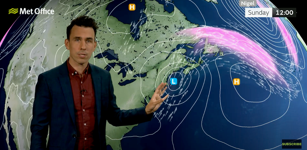
Met Office meteorologist Aidan McGivern explains now Nigel will move towards the UK later this weekend
|Met Office
It is forecast to arrive later this weekend with experts predicting calmer, cooler weather on Saturday before the deluge arrives on Sunday.
Met Office meteorologist Aidan McGivern said: “Trouble looms to the west of the UK in the form of an ex-hurricane, Nigel.
“Nigel gets caught up into the jet stream flow and begins to dance around an area of low pressure and eventually they merge in some form or another.
“The worst of the winds close to the centre of this ex-hurricane are not expected to cross the UK.
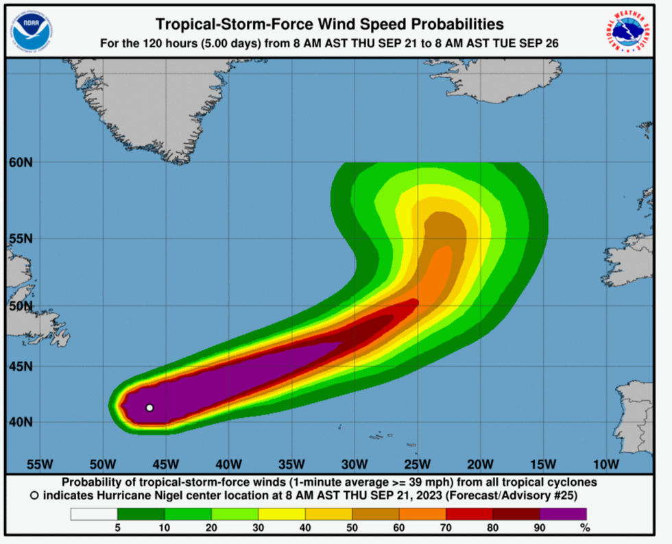
Hurricane Nigel moves towards the UK
|NOAA
“But, with the jet stream and with various remnants of the ex-hurricane circulating around that area of low pressure we are expecting some unsettled weather this weekend.”
Rain will turn heavier and more widespread into Sunday, with further wet and windy weather expected into next week, he added.
The UK will come under the influence of another tropical disturbance currently forming off the coast of Florida, he warned.
He said: “It is turning windier later Sunday as Nigel heads a little bit closer with some tightly packed isobars bringing gales to western and north-western coasts.
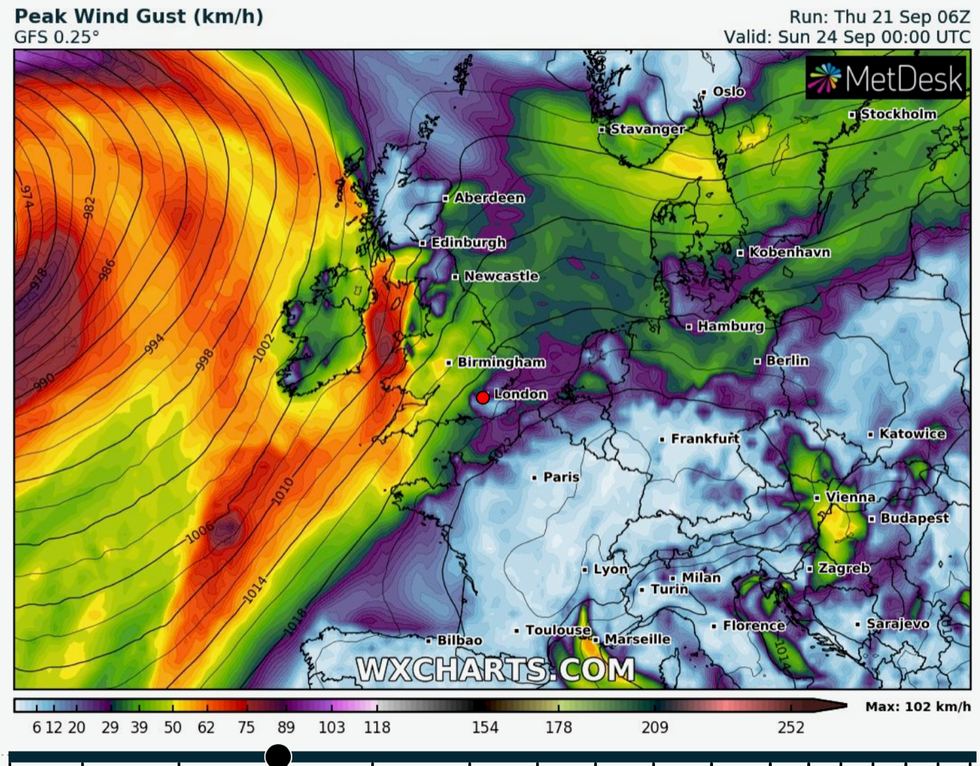
Strong winds associated with Nigel arrive later this weekend
|WX Charts
“A tropical system moves north along the eastern seaboard, gets picked up by the jet stream and by Sunday becomes influential on the weather in the north Atlantic.
“How that low interacts with the jet stream, and how the jet stream interacts with that low will have ramifications on our own weather into next week.”