


Britain is about to bake in the "hottest blast of summer so far" as battling weather systems bathe the nation in a plume of African heat.
Searing "heat spikes" due to surge up from the Continent from this week will plunge swathes of the UK into a 32C steam bath.
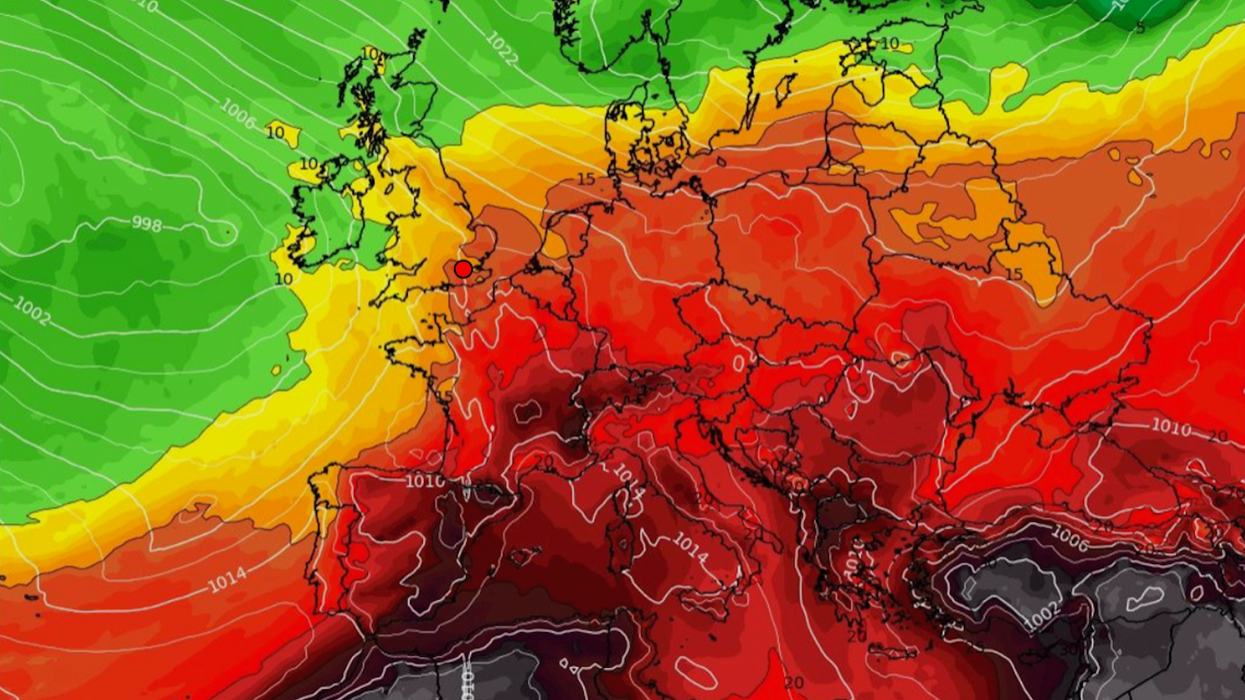
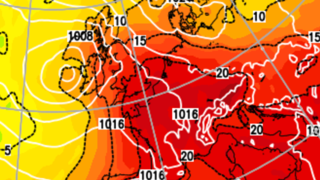
Temperatures will rocket ahead of the weekend as low pressure to the west tussles high pressure to the east, funnelling a channel of fire from Europe.
Southern regions will be first in line for summer’s return as weather models waver on how far north the hot weather will reach.
Temperatures will rocket ahead of the weekend as low pressure to the west tussles high pressure to the east, funnelling a channel of fire from Europe
|WXCHARTS
Jim Dale, meteorologist for British Weather Services, said: “Temperatures will rise later this week as hot air arrives from Northern Africa, through the Continent, Spain and France, and to the UK, and we could see 30C or up to 32C during this period of warm weather.
“Over the next fortnight, we will get spikes of heat which will bring further periods of warm to very hot weather.
“There will be frequent battles between the Atlantic and weather systems from the south, and this is what we expect this week, with low pressure to the west and high pressure to the northeast.”
Fierce heat will be driven by tropical air channelled into the UK between pressure systems straddling the country.
Soaring mercury will be boosted by above-average sea temperatures around much of the UK coastline.
As thermometers rise, humidity from weeks of wet weather will plunge Britain into a late tropical blast.
Dale, author of ‘Weather or Not?’, said: “We could get the hottest spell of summer so far, with temperatures possibly beating the current record for the year.
“As the ground is wet after all the rain we have had, when the heat builds it will feel very humid.
“In addition, sea temperatures around much of the North Sea coasts and the west coast are above average for the time of year, and this will help to drive the hotter weather.
“The big question is how long this will last, and currently it looks more likely than not that we will see hotter weather through the rest of August.”
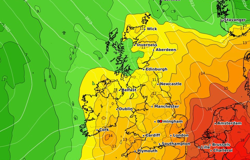
Unseasonably high temperatures could push parts of Britain past ‘heatwave’ thresholds, according to some forecasters.
High pressure will build from the south through the coming week pushing rain-bearing low pressure back out into the Atlantic.
James Madden, forecaster for Exacta Weather, said: “We now expect high pressure to return driving some very hot temperatures from the middle of August, and this could throw us back into heatwave territory.
“The hot weather could hold out beyond the end of the month and into the start of September.
“In the meantime, we are set to see a very hot peak of weather through the second half of August.”
Government forecasters say that after an unsettled start to the week, dry and sunny weather will set in ahead of the weekend.
Met Office meteorologist Aidan McGivern said: “Low pressure will continue to dominate on Monday.
Unseasonably high temperatures could push parts of Britain past 'heatwave’ thresholds, according to some forecasters
|Netweather
“Through the start of the week, that low will gradually start to fill, and there is a fairly strong signal for a ridge of high pressure to build over the UK.
“Gradually the weather will become less showery with a better chance of longer dry spells developing and some sunshine and slightly above-average temperatures, feeling pleasant where the sunshine comes through.”
Shifting weather systems will pull southerly winds into the country through the end of the week, he added.
He said: “The models suggest that high pressure over the UK will edge further east and low pressure will approach from the west.
“With this you would have a southerly airflow, and you would have some warmer weather from the south.
“This would bring a lot of fine weather, and some warmth, but there will be the potential for some thunderstorms.”
Met Office deputy chief meteorologist Rebekah Sherwin added: “The most likely scenario is for high pressure to the east and low pressure to the west, which would allow a southerly flow to develop and draw warmer air from continental Europe over the UK.
“With this scenario, temperatures into the low 30Cs are possible in the southeast towards the end of next week or over the weekend.
“What’s less clear from our models is how far north this warmth may spread from the southeast, how long it will last and the exact dates that warmer weather might exert its influence.”