


Britons have been warned that tornadoes "can't be ruled out" as a supercell thunderstorm seeks to unleash lightning and large hail upon the UK.
While most of the UK soaks in a glorious 32C heatwave, other parts of the country are at risk of a severe thunderstorm.
The Met Office issued a yellow thunderstorm warning yesterday morning, telling Britons “scattered thunderstorms may cause some impacts Saturday afternoon, into the evening and night”.
Lasting from 3pm on Saturday until 4am on Sunday morning, the Met Office has warned East Midlands, North East England, North West England, Yorkshire & Humber, Wales, and parts of the West Midlands will all be affected.
Britons have been told to expect sudden flooding, power cuts and lightning strikes.
The national forecaster warned: “Whilst many places will likely remain dry and unaffected, scattered thunderstorms may develop during Saturday afternoon, lasting through the evening hours, moving northeastwards before eventually clearing to the North Sea by the early hours of Sunday.
“The most intense thunderstorms could produce frequent lightning, large hail and gusty winds, along with some heavy downpours for a time.
“This may lead to some surface water impacts in places.”
LATEST DEVELOPMENTS: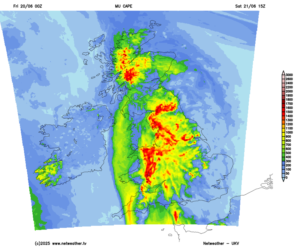
Large amounts of CAPE forecast by UKV across central, northern and western areas Saturday afternoon
|NETWEATHER
However, a forecast from NetWeather goes one step further, warning the weather system could develop into a “supercell thunderstorm”.
Netweather forecaster Nick Finnis wrote: “Elevated heavy showers and some thunderstorms are likely to move NE across western then northern areas through the day.”
He added: “Storms will form in an environment of fairly strong deep layer shear (40-50 knots), which combined with high CAPE (Convective Available Potential Energy), will allow storms to organise, perhaps into one or two supercells or bowing line segments capable of producing large hail and strong wind gusts.
“Intense rainfall leading to localised flooding and frequent lightning is also likely.
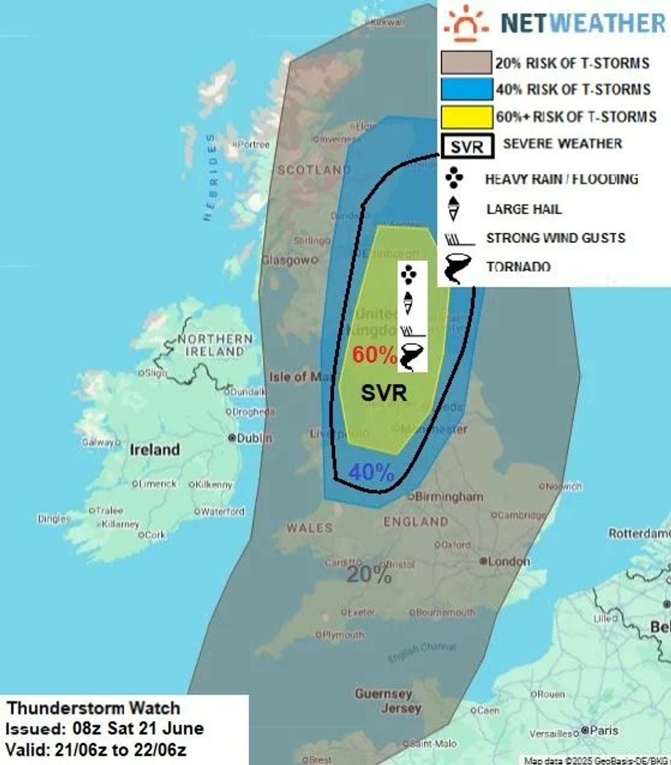
Netweather map shows tornadoes could strike within thunderstorm warning zone
|NETWEATHER
“Strong storm-relative helicity is also forecast across central and northern England, so a tornado or two can’t be ruled out if storms become surface-based.
“A severe area has been delineated for the aforementioned areas.
“Heavy showers and isolated thunderstorms may also develop and push northeast elsewhere across England further south and east during the evening.”
Looking further ahead to Sunday, Britons can expect a residual warmth to linger across East Anglia and into South East England with temperatures likely to reach between 25-27C.
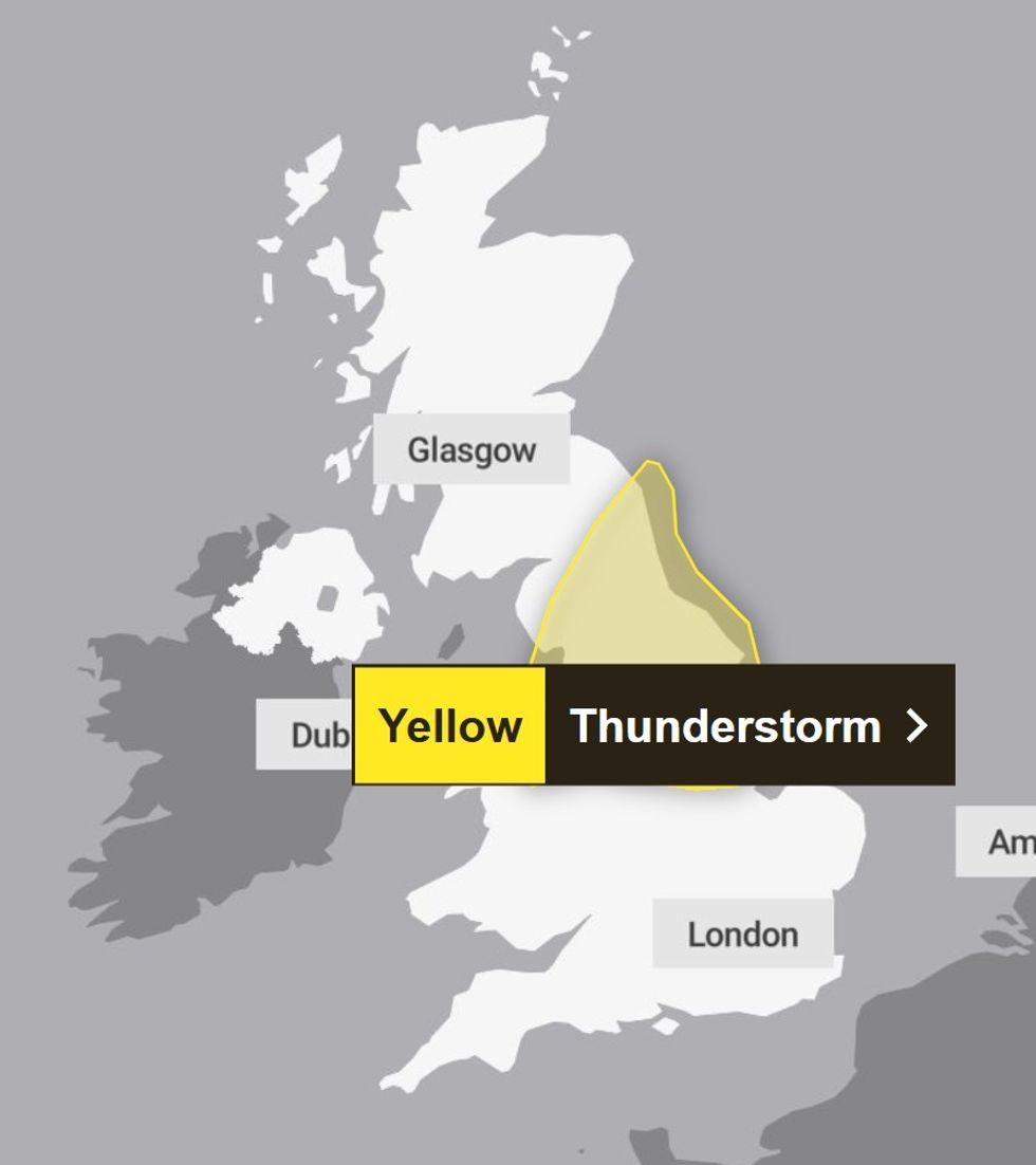
A Met Office thunderstorm warning will come into effect from 3pm on Saturday and last until 4am Sunday
|Met Office
Next week, Finnis has suggested, looks more changeable.
He said: “A more changeable outlook next week, with an increasingly active jet stream, driven by a steep contrast over the North Atlantic and North America, pushing east across the UK.
“This will mean areas of low pressure moving close or over northern UK, with frontal systems passing through - bringing spells of rain or showers but also some drier, brighter weather to many areas.
“Though the chance of rain in the south may become towards the end of the week, as the jet stream shifts north - allowing high pressure to build back in from the Azores, bringing increasingly drier, warmer and more settled conditions in the south.
“But some uncertainty about how quickly it will become more settled in the south.
“So, maybe good news for those going to the Glastonbury Festival - which starts on Wednesday and goes through to Sunday, it could start changeable with chances of rain, but turning drier and warmer, perhaps hot over the weekend.”