


Britain is on Easter storm alert with a powerful cyclonic weather system threatening to unleash a bank holiday washout.
A deep low-pressure cell barrelling into the UK during the weekend could arrive armed with torrential downpours and gales.
While fluctuating weather models may let Britain off the hook in time for the holiday, early signals are grim.
Jim Dale, meteorologist for British Weather Services, said: “This could be a major low-pressure storm hitting the UK, and the next few days of calm weather will give a false sense of security.
TRENDING
Stories
Videos
Your Say
“We are talking very strong winds, gale force or possibly storm force, in the north of the country and widely gusty.
“There will also be the risk of heavy showers and thunder.”
Unsettled weather is likely to head in on Friday with unsettled weather persisting through the bank holiday, he warned.
Its impact will be greater with the worst of the weather driving through as people are travelling for Easter, he added.
He said: “If this does come off as it looks like currently, it is going to be disruptive because of the timings, during the bank holiday when people are out and about.
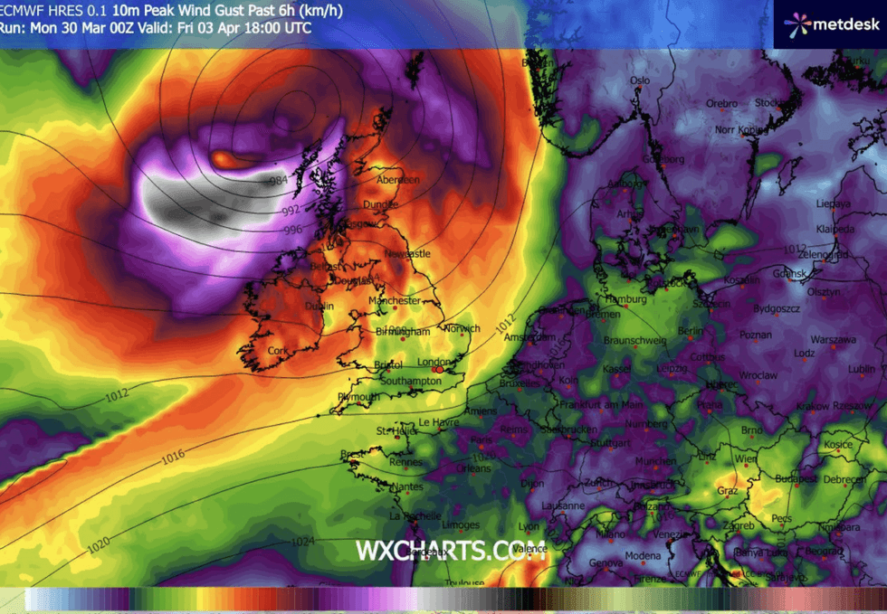
WX Charts map shows Britain to be In the crosshairs of an Easter Storm
|WX CHARTS
“The low, at the moment, looks like it comes in on Friday and Saturday, and then things look very messy towards Sunday.
“The potential for disruption is definitely there.”
Britain is being sandwiched between two weather systems, a huge dome of high pressure to the south and low pressure to the north.
The shifting and position of these systems will decide whether Friday’s storm hits the UK or moves further north.
LATEST DEVELOPMENTS:
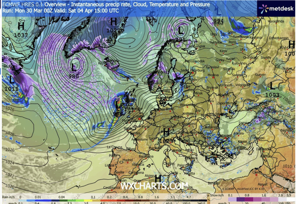
Stormy weather heads in during the bank holiday
|WX CHARTS
Government forecasters reckon high pressure to the south later in the weekend will calm things down.
However, the battle between cyclonic and anticyclonic weather patterns will keep Britons on their toes during a generally unsettled period.
Met Office meteorologist Annie Shuttelworth said: “There are potentially some quite strong winds for northern areas throughout the bank holiday.
“As the weekend goes on, low pressure becomes more likely, and this would bring in westerly winds, not particularly cold direction, but a not particularly warm direction.
“And we could see some fairly persistent rain and some strong winds, and the Saturday to Sunday period is looking like it could be most likely to be the most unsettled period.”
High pressure from the south may move back in on Monday, she added, bringing drier spells for parts.
She said: “It looks like that for much of the Easter holidays, we will be situated between high pressure and low pressure.
“It isn’t going to be particularly cold, but it isn’t going to be particularly dry, and we are most likely to get the drier.
“It doesn’t look like it is going to be a complete washout through the weekend, but there isn’t a strong signal for a long-lived sunny spell throughout Easter.”