









The Met Office has issued a fresh thunderstorm warning covering large swathes of Wales and the southeast.
The yellow-level alert, which will come into force from 3pm today and last until midnight, is set to see “torrential downpours of rain”.
Affected areas will predominantly be in Wales and South West but the national forecaster has said parts of Hampshire and the West Midlands such as Herefordshire, Shropshire and Worcestershire, could also be impacted.
Britons have been told to consider whether their location is at risk of flash flooding and if so to prepare in case of emergency.
The Met Office said: “After another hot day, thunderstorms are expected to develop across parts of Wales as well as some western and southwestern parts of England during this afternoon and through the evening.
“While many places will miss the worst conditions, where thunderstorms do occur they bring the potential for torrential downpours of rain, frequent lightning, large hail and strong, gusty winds.”
It adds: “There is a good chance driving conditions will be affected by spray, standing water and/or hail, leading to longer journey times by car and bus with delays to train services possible.
“Probably some damage to a few buildings and structures from lightning strikes.
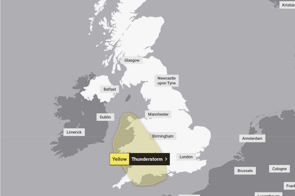
The Met Office has issued a fresh thunderstorm warning covering large swathes of Wales and the southeast
|MET OFFICE
“Some short-term loss of power and other services is likely.“Some flooding of a few homes and businesses possible, leading to some damage to buildings or structures.”
Met Office spokesman Stephen Dixon told GB News: “As often accompanies warm weather, the risk of thunderstorms increases for some this afternoon for parts of the southwest of England and parts of Wales.
“It’s important to note that many in the area will avoid the thunderstorms altogether, but where they do develop, they have the potential to bring some disruption, with some heavy bursts of rain, frequent lightning and hail possible.
“It’s not possible to pinpoint exactly where the thunderstorms will develop, but the warning area shows where this is possible, even if many will miss impacts altogether.”
The warning comes after Britain was hit by two consecutive days of record-breaking hot weather.
One official reading in Kew Gardens recorded a maximum of 35.1C on Tuesday, breaking a May record set only-one day prior when the same device measured 34.8C.
Such temperatures have not been hit since the joint record in 1922 and 1944 of 32.8C.
LATEST DEVELOPMENTS:
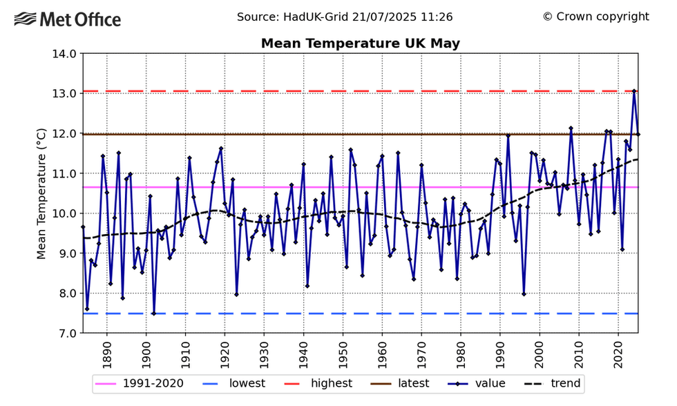
Chart shows UK Mean temperature for May from 1884 to 2025 - The brown line shows the 2025 value and the red dashed line shows 2024, which is currently the highest on record
|MET OFFICE
Overnight temperatures also proved unbearably hot, with the record for the highest daily minimum temperature for May also being broken for a third consecutive night.
To verify the new records, the equipment and site will undergo a rigorous validation process before a decision is made on officially inducting the figure into the meteorological record books.
This process will include a site inspection and a verification check of the equipment used to measure the temperature.
Today, the Met Office forecast says cloud and a developing easterly flow will lead to a reduction in temperature highs for many areas.
The areas today which are set to record the highest temperatures will be in the west and southwest of England where the thunderstorm warning is in effect and temperatures could reach 32-33C.
By Sunday, the warmest air is expected to have cleared away to the south with temperatures closer, though mostly above, average for the time of year for the whole of the UK.
Met Office Chief Forecaster Andy Page said: “The exceptional late-spring heat is set to continue for much of this week.
“Last night provisionally recorded the warmest May night on record, and we’re likely to see further very warm nights in the south over the coming days.
“There is a chance a few places will experience a ‘tropical night’ in the south of England and in Wales tonight, which is where temperatures don’t fall below 20C.
“While many places will stay dry and sunny, the heat and humidity mean that a few isolated thunderstorms have developed with more possibly developing later today, particularly across parts of England.
“Looking further ahead, the focus for the highest temperatures will shift westwards on Wednesday, with northern areas feeling more of the warmth on Thursday.
“We’ll then see a gradual change later in the week, with temperatures easing slightly, though still above average, before a more marked change to near-normal temperatures by Sunday and an increased chance of showers and some longer spells of rain.”