


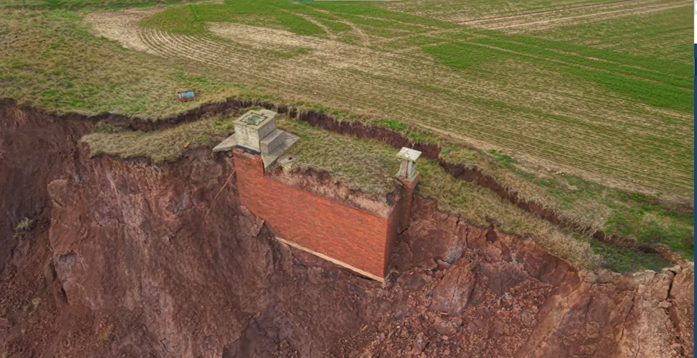
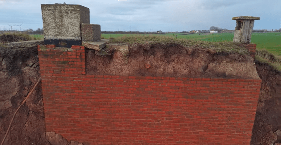
A Cold War-era nuclear bunker perched precariously on the East Yorkshire coastline could plunge into the North Sea within days, according to local observers documenting its demise.
The brick structure near Tunstall, constructed approximately seven decades ago as a lookout facility in case of atomic warfare, now sits exposed on rapidly crumbling clay cliffs.
Amateur historian Davey Robinson, who has been monitoring the site, told the BBC: "We live on one of the most eroded coastlines in Europe and this bunker hasn't got long left, perhaps just a few days."
The structure has been partially visible protruding from the cliff face since at least August.
Robinson and his partner Tracy Charlton have spent the past nine mornings trekking to the clifftop location, anticipating the moment the structure finally gives way.
The pair have been uploading daily footage to their YouTube channel, dubbing the project "bunker watch" – a series that has captured attention from viewers across the globe.
"We are posting the footage on our YouTube channel and it's getting interest from around the world," Robinson said.
Their recent video showing the bunker's condition following Storm Goretti has drawn thousands of views, with some commenters even placing wagers on when the structure will ultimately succumb to the waves.
The facility is believed to have been constructed in 1959 and closed in the 1990s
|TIMOTHY'S TRAVELS YOUTUBE
The facility, officially designated Tunstall ROC (Royal Observer Corps) Post, is understood to have been constructed in 1959 and remained operational until the early 1990s when the Cold War drew to a close.
Robinson explained that the bunker contained basic sleeping quarters and rudimentary living arrangements for personnel stationed there.
He said: "It was designed so that people could live inside it and just wait for a nuclear explosion to register and they could tell other people in other bunkers around the country.
"It never got used thank goodness."
LATEST DEVELOPMENTS
The Holderness coastline loses land at an average rate of roughly two metres each year
|TIMOTHY'S TRAVELS YOUTUBE
The post is among more than 280 similar monitoring stations scattered across Britain, according to historical research group Subterranea Britannica.
The Holderness coastline loses land at an average rate of roughly two metres each year, according to Environment Agency figures.
Since Roman times, an estimated five kilometres of terrain has disappeared beneath the waves, taking some 23 villages with it.
Robinson described the bunker as "a symbol of erosion in this area", adding: "This whole area is eroding at a rapid rate and to see an actual physical thing moving it just shows what's happening really."
East Riding of Yorkshire Council has issued a warning urging members of the public to keep away from both the clifftop and beach, maintaining a safe distance from the unstable cliff base.