


A ‘dangerous heat dome’ rolling into the US from the Caribbean threatens a three-month ‘triple-digit’ heatwave.
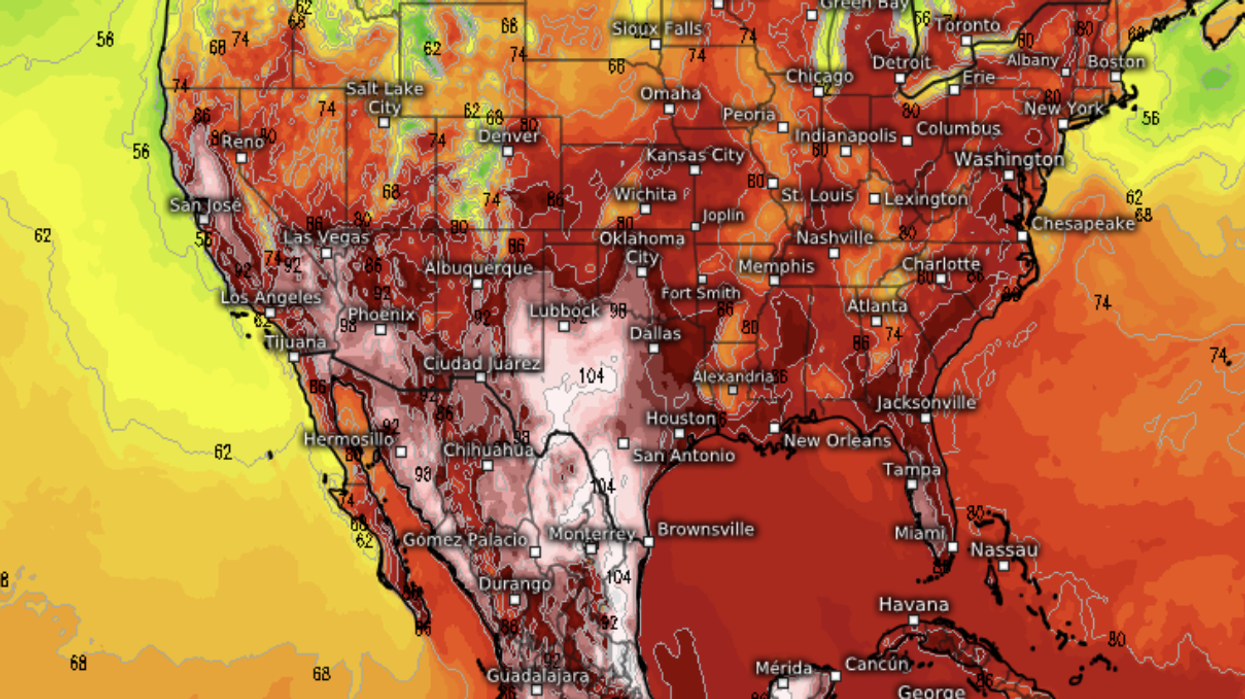
A rare ‘excessive heat warning’ has been issued across four states where thermometers are poised to nudge 105F.
Records are expected to tumble over the coming days as temperatures surge 30F higher than average.
As swathes of the United States brace for a dangerous heatwave, experts warn of no relief this side of autumn.
Jim Dale, US weather correspondent and meteorologist for British Weather Services, said: “The main story this week is going to be the heat, and some southern states are going to see some extraordinary temperatures through the next few days.
“We are now in dangerous-heatwave territory as this plume of hot air comes out of Mexico and the Caribbean.
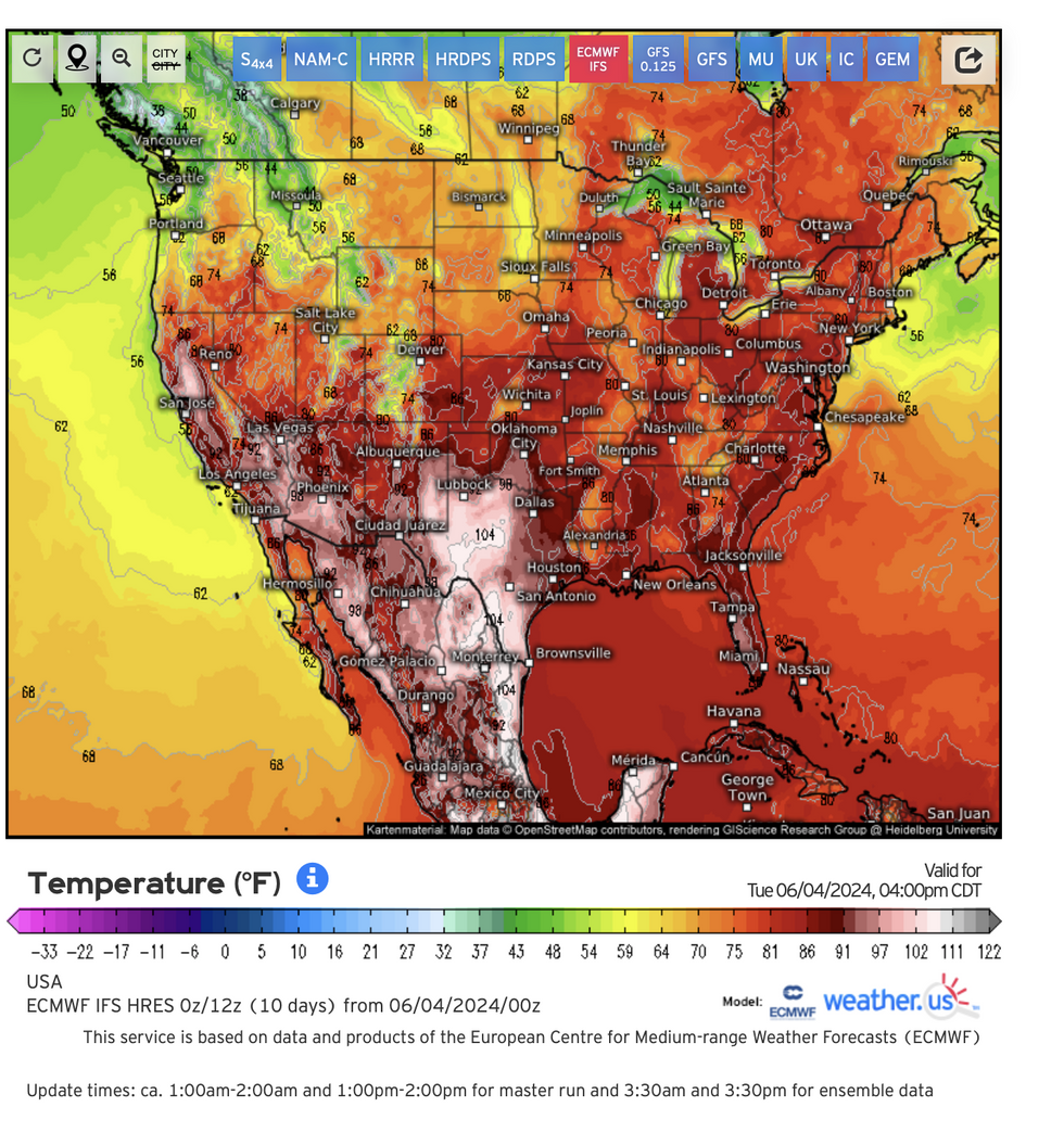
Temperatures are set to rise above 100F
|WEATHER.US
“This will remain a risk for the next three months, and although that doesn’t mean there won’t be any interruption, we are looking at an inevitable march into a very hot period of weather.”
Extreme heat baking Mexico will move through the coming weeks from the south and the southwest towards central states.
Experts blame a ‘heat dome’, a region of high pressure trapping hot air, which is moving in from central America.
Lack of rain in regions worst affected by the roasting heat also threatens drought as Mexico suffers the worst dry spell since 2011.
AccuWeather long-range meteorologist Paul Pastelok said: “A massive heat dome parked over Mexico will begin to shift northward and into the southwestern and south-central states.
“There is the potential for a prong of triple-digit heat to develop over the interior valley of California by the middle of the week.
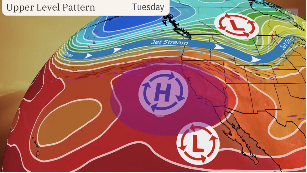
Heat dome forms under the jet stream
|THE WEATHER CHANNEL
“Temperatures will significantly trend upward as a bubble of heat from Mexico moves up and into the western United States."
Wildfires sweeping Mexico will send plumes of smoke into southern states, impacting air quality, he warned.
Rising temperatures and moisture from the tropics threaten a thunderstorms across the region, he added.
He said: “As the transition to summer begins in June, moisture from the tropics will increase over southern Mexico and slowly progress northward over the country.
“There already has been some influx of moisture into the southern part of Mexico in the form of spotty showers and thunderstorms in the past couple of weeks."
The deadly heat dome–caused by pressure building in the upper atmosphere–could put people with health conditions at added risk.
Weather Channel meteorologist Jonathan Erdman said: “A heat dome, or upper-level area of high pressure, will build to the west this week raising temperatures.
“Daily record highs are possible with temperatures soaring 10F to 15F hotter than average for parts of the region.
“Low temperatures won’t offer much relief overnight with lows only dipping into the 60Fs, 70Fs and 80Fs.
“The daytime heat and the warm lows will be a dangerous combination and raise the risk of heat illnesses in areas under heat advisories and warnings through late this week.”
A spokesman for NOAA added: “High temperature anomalies of 20F to 30F degrees above average are likely.
“Widespread temperature records are expected to be tied or broken across many affected areas.
“Excessive Heat Warnings and Watches extend from the central valley down
through southern California's deserts, southern Nevada, and southern and western Arizona.”