
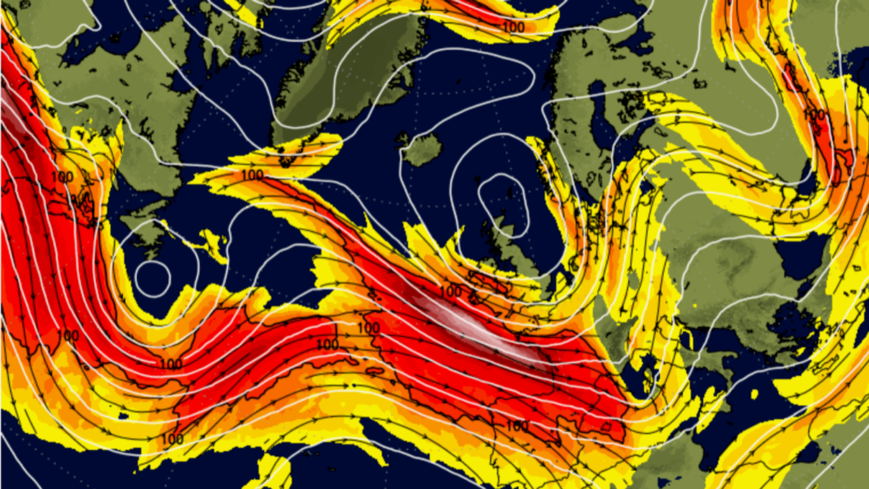


A 200mph ‘jet streak’ about to surge over Britain has meteorologists ‘looking over their shoulders’ for the next mega-storm with further weather turbulence ahead.
Wind and rain will return in the run up to the weekend as relentless Atlantic cyclones doom any chance of ‘lasting settled conditions’.
The barrage will be driven by the jet stream, currently building core speeds of 200mph at its centre–the jet streak.
The jet, whose average speed is around 110mph, will swoop past the UK later this week bringing the brief calm after Storm Ciaran to a volatile end.
Jim Dale, senior meteorologist for British Weather Services and social commentator, said: “There are a few lows coming in again after the calmer start to the week, and once again we are going to be looking over our shoulder for the possibility of another disruptive storm.
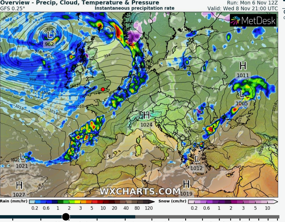
UK weather: Low after low hits the UK
|WX Charts
“Part of the reason for this is the jet stream which when strong, will always have the potential to strengthen low-pressure systems from the Atlantic into something powerful.
“The west of the country is going to be particularly wet this week with another couple of inches of rain on the way, and while this doesn’t sound like a lot it is around two times the average.
“For the next few days, it is going to be a watching and waiting exercise.”
Weather models show the UK in the direct path of a series of low-pressure systems ploughing in from the Atlantic.
Low pressure, the driver for unsettled conditions will dominate the weather, with no sign of sustained high pressure, the driver for calmer weather.
Mr Dale said: “There is no sign in the forecasts of any long-term settled weather, as the weather will be dominated by low pressure for the next week at least.
“There is no sign of any high pressure, which is what would be needed to bring the calmer weather.”
Longer range outlooks suggest that the stormy weather will be followed by a chilly taste of winter.
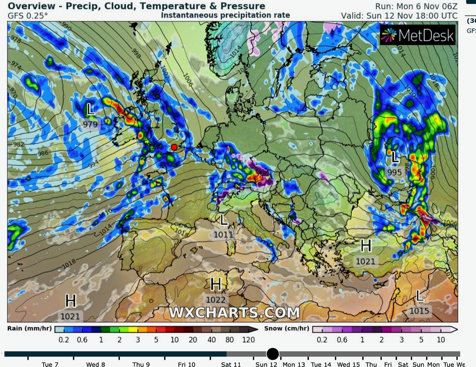
Low pressure keeps hitting the UK
|WX Charts
Parts of the country could be in for the first significant snow of the season as soon as the middle of November.
The first flurries will hit the Highlands of Scotland as temperatures nosedive through the second half of the month.
James Madden, forecaster for Exacta Weather, said: “We are now looking at the possibility of winter temperatures bringing widespread frosts from mid-month, or perhaps a little earlier.
“With this will be the risk of a notable wintry blast during the latter part of the month and into the start of December.”
Bookmakers Ladbrokes are now odds on for snowfall this month with a 6/4 shot on a White Christmas.
Spokesman Alex Apati said: "Temperatures have already taken a turn for the worse and the latest odds suggest the white stuff could even make an appearance before the end of this month."
North-western England will be most at risk of showers through this week, according to the Met Office.
Meteorologist Aidan McGivern said: “The good news is that this week is looking less wet and less windy, but you wouldn’t exactly call it dry or calm because the jet stream will continue to feed us areas of low pressure from the west.
“The jet stream has weakened and become a bit more loopy, and it will bring low pressure systems that are a bit more typical for November, with some wind and some rain and some showers coming in from the west.”