


A giant, "flabby" pressure cell wobbling stubbornly over the UK in the wake of Hurricane Erin threatens a "false autumn" washout.
The huge low-pressure cyclone comprising the tropical remains will sit to the north, dragging in "frontal system after frontal system".
Downpours into the weekend will turn heavier, more persistent and increasingly widespread as families enjoy the end of the holidays.
**ARE YOU READING THIS ON OUR APP? DOWNLOAD NOW FOR THE BEST GB NEWS EXPERIENCE**

Downpours into the weekend will turn heavier, more persistent and increasingly widespread as families enjoy the end of the holidays
|WXCHARTS
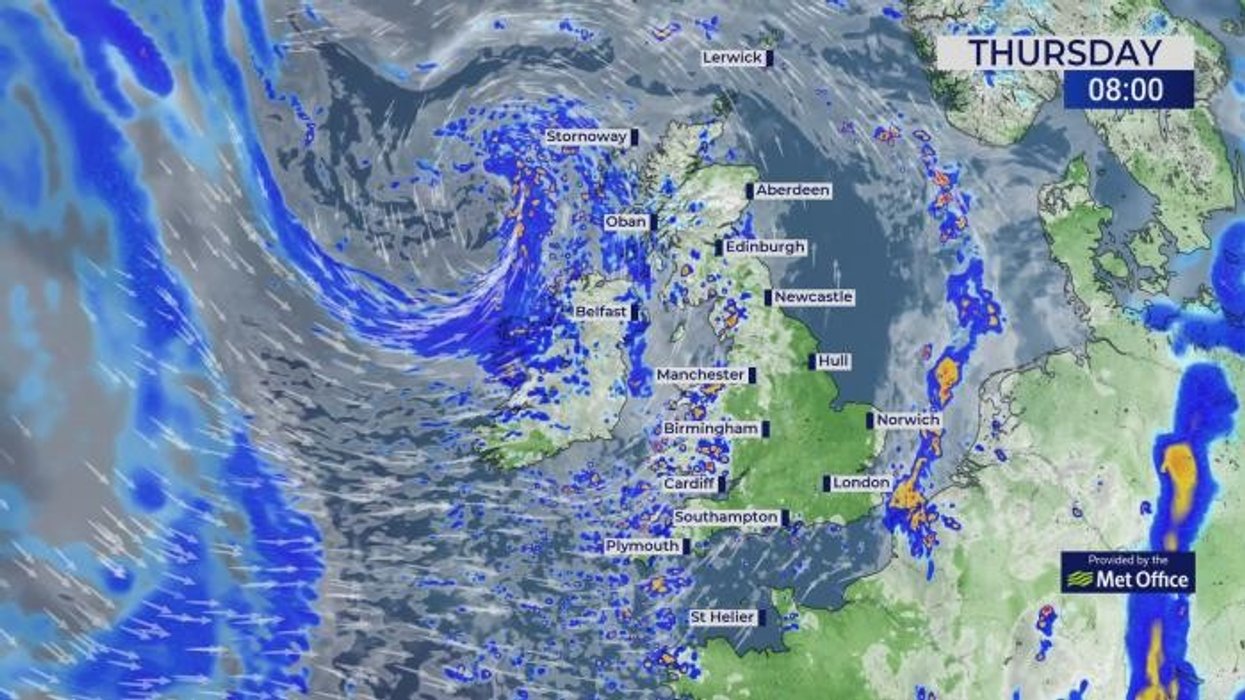
A yellow weather warning has been issued until 4pm today in Wales as forecasters warn of possible flooding.
Met Office meteorologist Honor Criswick said: “Later Thursday and into Friday we see more persistent outbreaks of rain move through.
“An area of low pressure starts to become a ‘flabby low’, and that means that it is not such a well-defined area of low pressure, with the winds not quite as strong, and it doesn’t have a well-defined frontal system bringing through outbreaks of rain, and it continues to drag in frontal system after frontal system.
“But as we head into the weekend, we continue to see low pressure dragging in systems from the Atlantic, and on Saturday low pressure pushes into the south and the southwest.”
The troublesome feature is the remains of Hurricane Erin after hurtling across the Atlantic, died in the cold waters of the North Atlantic.
It nudged the jet stream to bring an unusually warm bank holiday and is now acting like a spinning washing machine stuck over Britain.
Wet and windy weather will be the theme through the weekend and into the start of September.
And it will feel cooler compared to the past few days with temperatures dipping closer to average, into the low-20Cs.
Criswick said: “Even from Sunday, we will still remain in that westerly flow, with a Polar Maritime airmass, so there will be longer spells of rain and at times it could be quite breezy, but hopefully there will be some brighter interludes in between.
“Through the week, we see a slight drop in temperatures, but they will be in the high teens to low-20Cs, which is more towards average for the time of year.
“Over the past week it has felt quite autumnal, and this is referred to as a ‘false autumn’, which happens when we have a long dry hot summer with drought in parts of the country.”
The deluge will arrive after what experts reckon will shape up to be the warmest UK summer on record.
Consistently high average temperatures over the past three months could put 2025 into the record books, according to Government meteorologists.
Met Office scientist Emily Carlisle said: “Provisional Met Office statistics show that summer 2025 will almost certainly be the warmest summer on record.

Met Office’s Honor Criswick points out a giant flabby low lingering over the UK in the wake of Hurricane Erin
|MET OFFICE
“Unless temperatures are around four degrees below average for the rest of August, which the forecast does not suggest, it looks like the current record will be exceeded.
“This would move 1976 out of the top five warmest summers since 1884, leaving all five warmest summers having occurred since the year 2000.”
It will come as little comfort, however, for those hoping to catch one last heat burst for the end of summer.
Jim Dale, meteorologist for British Weather Services and social commentator, said: “It is an unsettled theme going forward, and there are no signs of another heatwave on the scale that we saw earlier in the season.”