


Britain is facing a Nordic Nightmare with a snow-laden ice blast from the Norwegian Fjords about to sweep the nation.
A -5C wall of snow heading in from the north threatens to dump inches of the white stuff over Scotland as the UK braces for possibly the worst winter assault for a year.
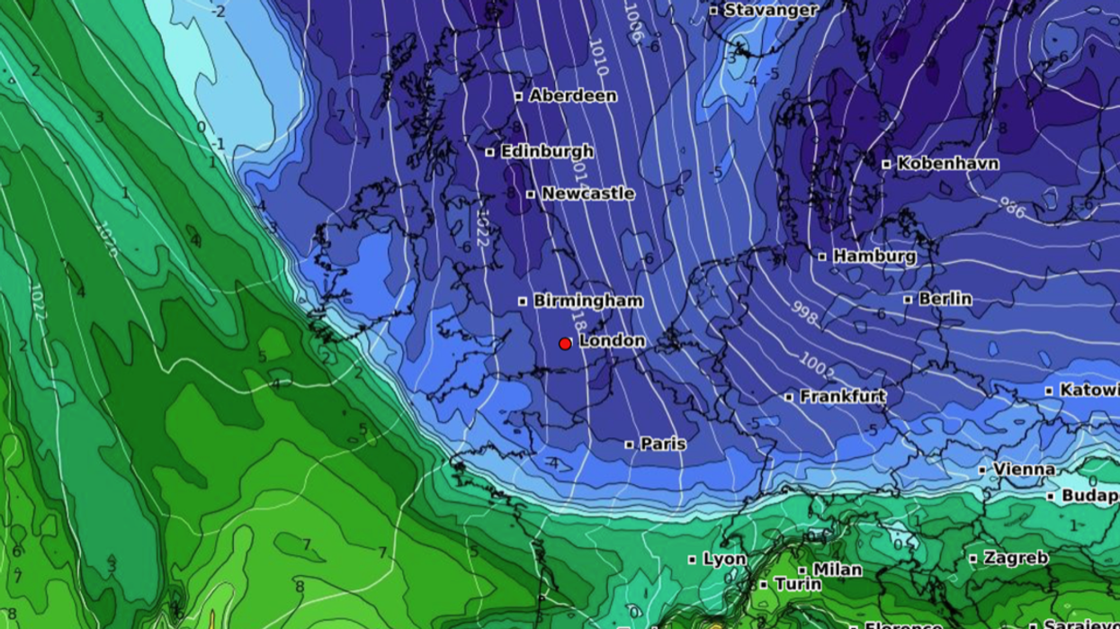
Bitterly cold air from the Arctic will surge southwards ahead of the weekend, crossing the Scandinavian coast before ploughing into Britain.
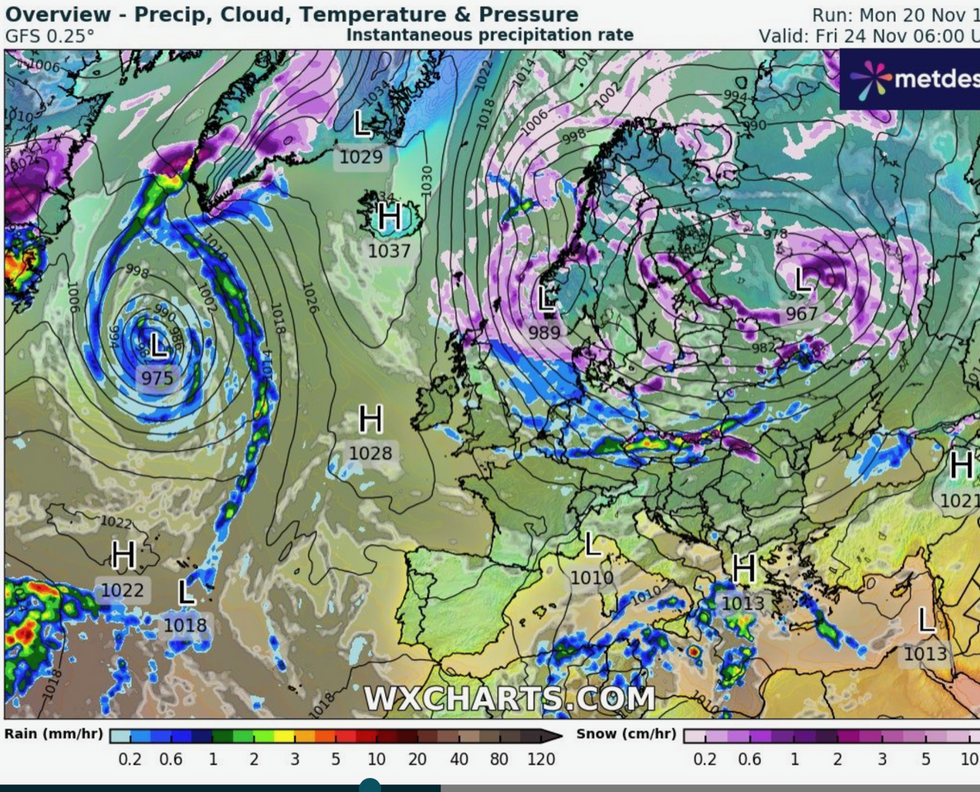
It will be dragged through the UK into France by a huge low-pressure cyclone spinning over Scandinavia.
WATCH HERE: UK weather outlook 21/11/2023
Jim Dale, meteorologist with British Weather Services and social commentator, said: “This is modified air coming in from the Arctic, across Scandinavia where a huge low is pulling a northerly down from the Polar region, acting in combination with the Azores High in the Atlantic.
“It is going to come all the way across the UK by the end of the week, and then it will be pulled into France.
“We are going to feel a proper northerly blast, and there could be significant snow over the Highlands and the Grampians.”
Ground temperatures will widely sink to freezing with bitter gusts making it feel much colder.
LATEST DEVELOPMENTS: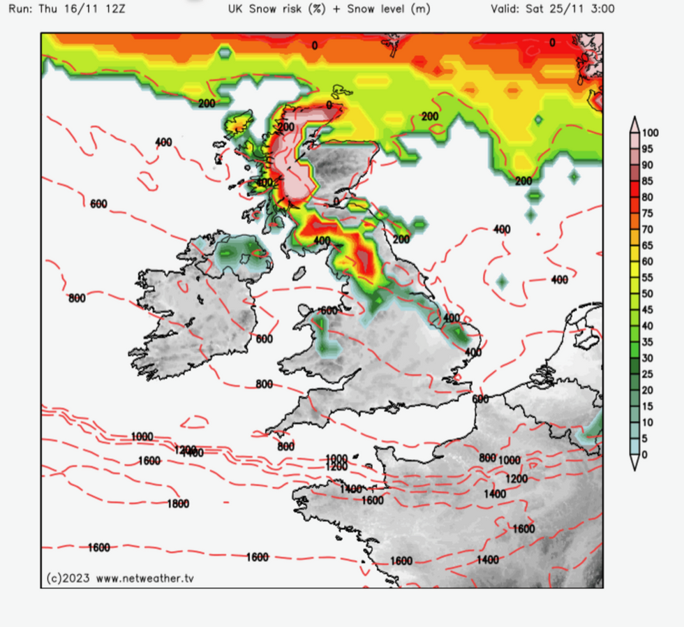
Wall of snow heads down from the north
|netweather
‘Feels-like’ temperatures by the end of the week could hit -5C in exposed regions of the north, Mr Dale warned.
By Friday, all of the UK will feel a taste of the Arctic, although Scotland and northern England will bear the brunt, he added.
“Friday is the first proper day the cold will really get into the UK, and this is when we will really start to feel the first real taste of winter this year,” he said.
Weather charts reveal heavy snow hitting parts of Scotland ahead of the weekend, with flurries possible further south.
Snow blast circles Scandinavia before heading south
|WX charts
Parts of eastern England and even central and southern regions might see a flake or two during the blast, experts warn.
James Madden, forecaster for Exacta Weather, said: “The first major wintry blast of the season will arrive later this week, and from Friday, we are expecting to see snow as Arctic air spills across the country.
“There is some uncertainty as to how far south this will reach, and the brunt of this wintry spell will be felt across the north of the country.
“However, eastern parts of England could see some snow, as could central and southern regions, and this could reach lower levels.”
As thermometers tumble, bookies have taken the axe to November snow odds with Ladbrokes offering 1-3 on a flurry this week.
Spokesman Alex Apati said: "The latest odds suggest we could be seeing snow a lot sooner than usual, with the white stuff now odds on to fall at any point this week."
The Met Office said colder conditions would follow an unsettled run up to the weekend.
Snow will be largely confined to the north at the end of the week, although temperatures will fall widely, government forecasters added.
Met Office meteorologist Aidan McGivern said: “We are expecting it to turn a little bit colder towards the end of the week.
“As a cold front sinks south, we are going to see cold winds arrive from the north.
“It is going to feel colder later this week, and there are going to be some snow showers over the hills of Scotland.”