


A monsoon deluge carried on a plume of tropical humidity threatens a weekend of torrential rain, gales and hail-laden thunderstorms.
Britain’s weather is about to show its fangs as the gates open to a barrage of Atlantic storms.
As wind and rain sweep the nation ahead of the weekend, temperatures will rocket fuelling the deluge.
Met Office meteorologist Alex Burkill said: “There will be some wet and windy weather to come as we go through this week.
“On Friday, more wet weather is coming in from the west, becoming more widespread with higher temperatures and high humidity, and thundery downpours are not out of the question.
“There are going to be a fair few showers at the weekend, and they could be quite slow moving with some hail and thunder mixed in.
“Towards the end of Saturday and into Sunday there could be some more persistent rain and stronger winds.”
A mid-week respite will bring a spell of calmer weather before Britain gets back on the summer roller coaster.

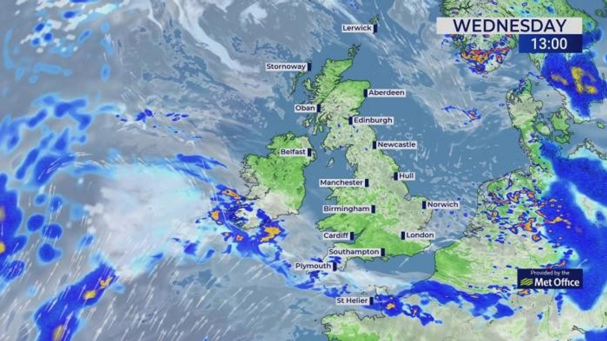
An overview of the weather for Sunday
|WXCHARTS
Temperatures in southern regions could hit the high-20Cs by Friday, although the west will face autumnal winds.
Burkill said: “As we go into Wednesday, we see something a little bit drier for a time, and for many it is looking largely dry.
“Temperatures are starting to climb up a little bit, and there will be some relatively high humidity.
“As we go into Thursday, things start to get a bit tricky, and I am expecting some wet weather to affect western and northwestern parts.

Showers are also expected on Saturday
|WXCHARTS
“There will be some showers towards the west and the southwest, and temperatures re creeping up to the mid- to high-20Cs, but there are still some strong winds, with western parts having some blustery winds.”
Temperatures will rise through the end of the week, nudging the high-20Cs again in parts of the south.
Energy in the atmosphere left from weeks of warm weather will fuel thunderstorms through the coming days.

Temperatures could also drop to around 20C
|WXCHARTS
Jim Dale, meteorologist for British Weather Services and social commentator, said: “There is a lot of latent energy in the atmosphere and in the ground and the sea after the hot weather since spring, and this is going to fuel the unsettled weather.
“Temperatures will fluctuate from cool to hot, but towards the end of the week, there are signs they will rise again possibly into the high-20Cs in parts.
“In the run up to the weekend, another low-pressure system from the west will bring the risk of heavy rain and unsettled weather, and with this will come the risk of flooding.”

Mercury could jump back into the mid-20s next week
|WXCHARTS
Atlantic storm systems will arrive with trailing weather fronts carrying heavy rain and whipping up strong winds.
Jason Nicholls, lead international forecaster for AccuWeather, said: “A front will spread eastwards across the UK this weekend, and this will bring rainy spells.
“Scattered showers are possible earlier in the week, on Thursday, although there will be sunny periods and isolated showers on Friday.”