
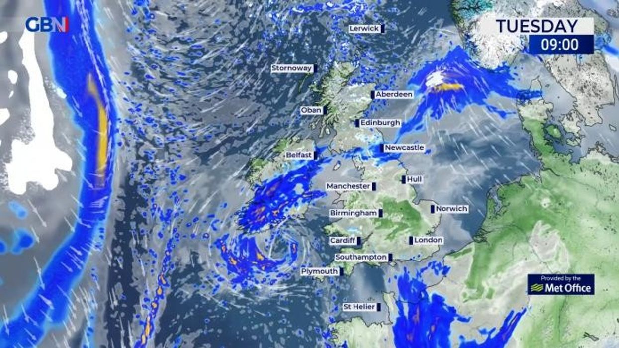


A ‘cyclonic’ weather pattern will shunt the cold weather in favour of stubborn and persistent rain, thunder and hail.
Arctic winds will plummet temperatures into mid-week with Scotland and northern England on alert for snow over the hills.
Temperatures will rise in the run-up to Easter, but the focus will then turn to torrential and explosive downpours.
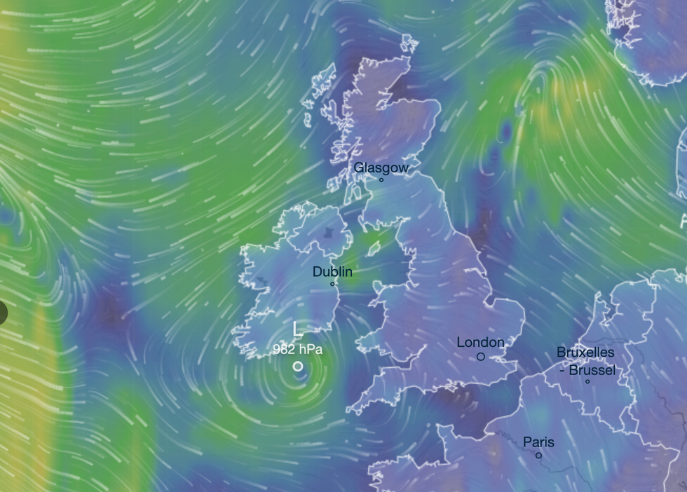
Stubborn low pressure in the Atlantic–known as a ‘cyclonic’ weather pattern–will mimic a washing machine, hurling bouts of wind and rain into Britain.
More than three inches of rain could hit parts of the country through the weekend with unseasonably wet and windy weather forecast into April.
Jim Dale, meteorologist for British Weather Services and social commentator, said: “It is going to be a fairly unsettled run up to what could be a difficult Easter period in terms of the expected rainfall, and this pattern is likely to continue through the next 10 or so days.
Arctic winds will plummet temperatures into mid-week
|VENTUSKY
“I would expect to see around two to three inches or more in parts during this period, and there is going to be a flood risk on the back of that.
“There is a lot of Atlantic activity, and low pressure close to the UK is going to dominate through the start of April, which is also looking highly changeable.”
Low pressure has driven weeks of changeable weather across the UK, with spring snow its latest offering.
A large low settled to the north-west of the UK this week, pulling a spiral of cold air down from the Arctic.
The risk of hill snow will persist across Scotland into the middle of the week when temperatures will recover.
However, an active jet stream will strengthen low pressure, keeping it close to the UK and driving the wet weather.
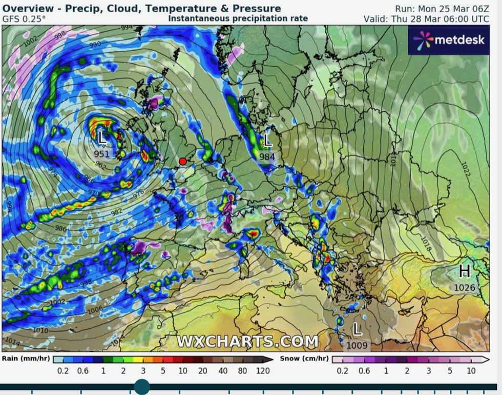
Low pressure spins to the west
|WX CHARTS
Met Office meteorologist Alex Burkill said: “It is fair to say that the weather in the run up to Easter is going to be a bit messy.
“We have an active jet stream that is going to dip down to the south of us, bringing some unsettled weather to Iberia this week, and from the UK’s point of view we are going to be stuck with low pressure to the west of us.
“We are going to feel likely we are stuck in a bit of a washing machine with various spells of wet and at times blustery weather.”
Heavy downpours will continue through the week with the risk of hail and thunder, he added.
He said: “We are going to have some hefty and perhaps thundery outbreaks across west and southwestern parts on Wednesday, and that will feed its way north-eastwards through the day.
“There could be some hail and thunder mixed in with these as well.
“Temperatures will be similar or just a touch higher than Tuesday, and as we go into Thursday we stick with low pressure to the west of us, and it is not going to go anywhere soon.”
Exacta Weather forecaster James Madden added: “It is a pretty showery and rather cool outlook for most going forward and around Easter.
“However, later this week this unsettled weather could coincide with colder conditions overnight once again, and this will bring the risk of some heavy and temporary snow.”
High pressure is expected to build to the north of the UK after Easter, although the south holds on to the wetter weather.
In the longer term, early signals suggest drier and warmer weather will eventually set in later next month.