


A weekend storm will open the doors to a fortnight of wind and rain as Britain becomes the target of a cyclonic conveyor belt.
Calm weather will collapse on Sunday as a deep low hurtles across the Atlantic from the American east coast.
Hitching a ride on the jet stream, it will strengthen on its path before hitting the UK with torrential downpours and gales.
Stormy weather could hold out until the end of the month as the jet provides a conveyor belt to low-pressure from the west.
Met Office meteorologist Alex Burkill said: “Into September, there are signs that the unsettled theme is going to continue, although as we go through the third week of September, there are signs of higher pressure at times towards the south, so there could be some quieter spells.
“However, these don’t look like big blocking highs that will last for ages, they may just be some temporary ridges.”
The immediate threat comes from a deepening storm system en route to the UK later this weekend.
Also hitching a ride on the jet stream, the storm is keeping meteorologists guessing as to how strong it will get and where it will hit.
LATEST DEVELOPMENTS: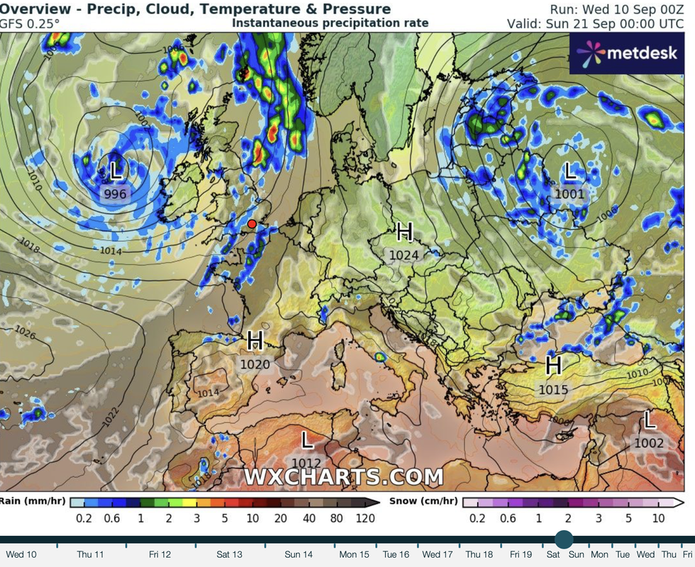
Low pressure, wind and rain close by through the month
|WX CHARTS
If it flips to the northern side of the jet, it will strengthen rapidly and deliver a more powerful hammering.
Some models, however, show it hovering to the south of the jet, where it will remain a weaker, ‘flabby’, system.
Burkill said: “On Thursday, this area of low pressure is going to start developing on the eastern side of the US, and then it pushes eastwards and gets caught up in the jet stream and comes across the Atlantic.
“The latest model wants to keep this low on the southern side of the jet and keeps it as quite a flabby feature, and comes across southern parts of the UK on Sunday, and if this comes off, it will be a wet and windy day across some southern parts.
“We think that the low is going to come across the jet stream, come across to the northern side, and then intensify and deepen as it comes towards the UK.”
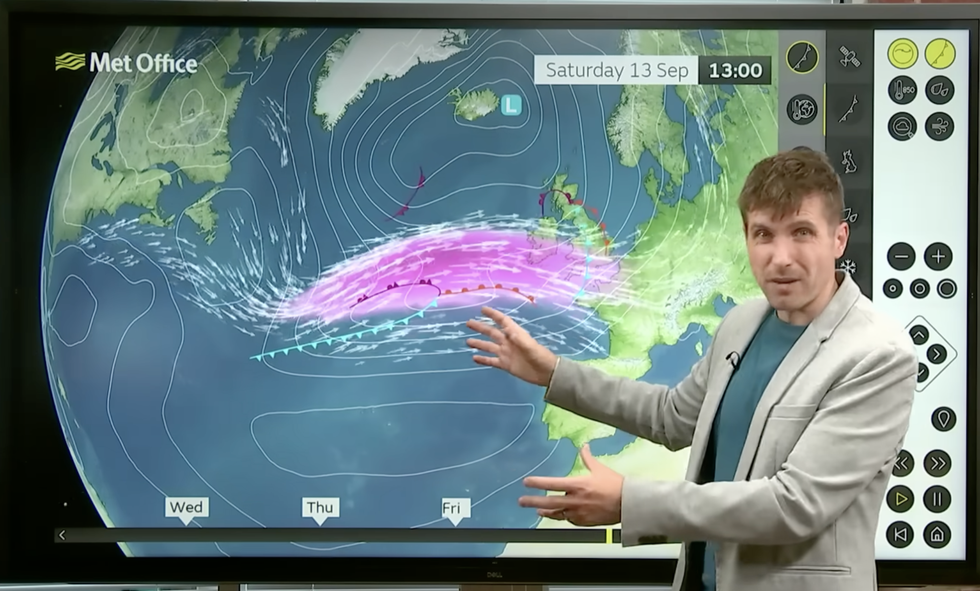
Met Office’s Alex Burkill describes the storm arriving on the jet
|MET OFFICE
A less-likely model outcome predicts a severe spell of weather across wider parts of the UK, he warned.
He said: “We have three possible scenarios as we go through this weekend, and the most preferred solution is for a deep low to develop across the Atlantic and end up to the northwest of the UK.
“This would bring some wet and windy weather, particularly to the west and the northwest of the UK, with gales or severe gales in places and there would be some wet weather sweeping through.
“Another possibility, with a 10-per cent chance, is for a deeper, more developed low to track across the UK, and if this comes off, it could be very wet and very windy quite widely.”
Independent forecasters agree on a potentially unsettled picture through the rest of the month.
An unusually dry spring and summer will drive the weather to balance with a glut of autumn wind and rain.
Jim Dale, meteorologist for British Weather Services and co-author of ‘Surviving Extreme Weather’, said: “September is likely to keep the unsettled theme, and this is largely due to the balancing effect of the weather which has been unusually dry over the past few months.
“In terms of storms, through the season as a whole, we could be looking at between three and six named storms, but this depends on the position of the jet stream and how it interacts with low pressure.
“Overall, there is a chance that the rest of the month will be changeable and unsettled.”