


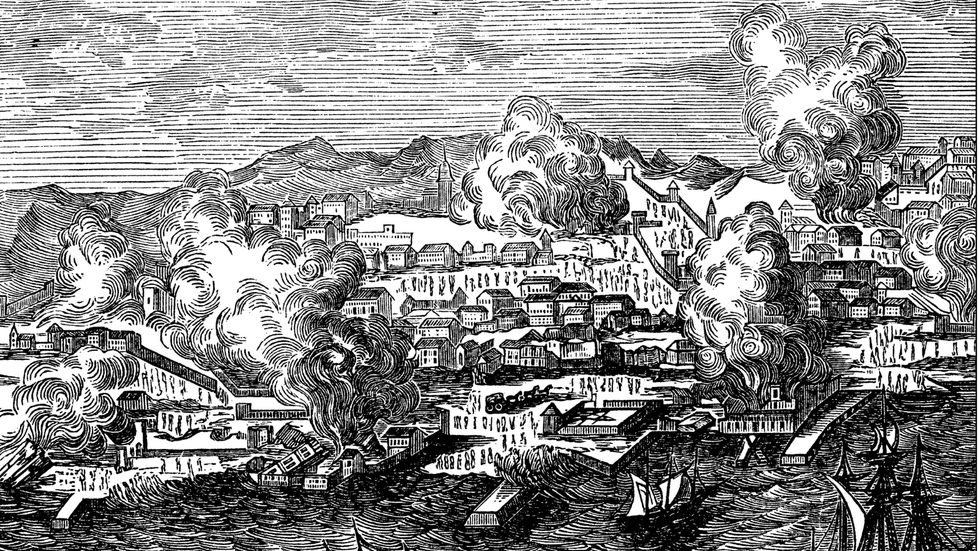
Scientists have identified what they think is the cause of an enormous earthquake which devastated Portugal almost 300 years ago.
Researchers from the University of Lisbon discovered that the 8.6 magnitude "megaquake" which hit the Portuguese capital in 1755, killing tens of thousands, was caused by a piece of tectonic plate sinking in the Atlantic Ocean.
The phenomenon, referred to as “lithosphere delamination”, has only been documented previously on land rather than below the waves.
The findings have been published in the journal Nature Geoscience, sparking debate within the scientific community around predicting earthquakes in Europe.
Scientists have identified a phenomenon believed to have caused an enormous earthquake which devastated Portugal almost 300 years ago
|GETTY
Scientists deployed complex earthquake mapping techniques as part of the study to gain greater insight into the Earth's structure in the deep waters of the ocean.
The researchers analysed data collected between 2007 and 2013 from 387 broadband stations on land across the Iberian Peninsula and North Africa.
Data from 24 seismometers situated on the seafloor off the Portuguese coast was also incorporated into the study.
Scientists were able to use the figures to craft a highly-detailed model of seismic wave movement extending from the crust-mantle boundary around 800 kilometres beneath the Earth.
The model helped researchers detect a high-velocity anomaly around 250 kilometres beneath the Horseshoe Abyssal Plain, a region renowned for its extreme seismic activity.
The plain is situated in the Iberian Peninsula's southwest, sandwiched between the Eurasian and African tectonic plates.
It was also the area from which the Lisbon earthquake of 1755 occurred, alongside other major European tremors including a 7.9 magnitude quake which hit San Vincenzo or Cape Saint Vincent in 1969.
Researchers did not discover any indicators of seismic risks, such as underwater mountains, in the region.
SCIENCE - READ THE LATEST:
- Archaeologists reveal secrets of grisly first-of-its-kind discovery beneath ancient Roman fort
- Scientists launch expedition to solve mystery of UK's 'vanishing lake'
- Archaeology breakthrough as eerie ancient burial of humans with hands tied behind back discovered
- Northern lights to light up British skies after stunning 'cannibal' solar storm strikes
However, scientists did observe that a chunk of the oceanic surface is sinking into Earth's mantle, which can lead to a tectonic plate sliding underneath another if the contact margin is compressed.
The study's co-author, Dr Chiara Civiero, said: “This discovery opens up new avenues for understanding the evolution of the very early stages of oceanic subduction with important implications for plate tectonics.
“If even areas without obvious surface faults, such as the Horseshoe Abyssal Plain, can be subject to strong earthquakes, there is a need to revise seismic hazard models to include deep processes and structures that cannot be mapped using traditional methods."
The areas most at risk of devastating earthquakes are found along Europe's southern coast, according to researchers from the Share project.

The areas most at risk of devastating earthquakes are found along Europe's southern coast
|GETTY
The most endangered countries include Italy, Greece, Bulgaria, Romania, Turkey and the Balkan states.
Josip Stipcevic, a geophysicist from the Faculty of Sciences in Zagreb, explained: "This has to do with the tectonics and geodynamics in the area.
"The cause is the Anatolian plate, which slides along the Eurasian plate to the north, turns to the south and the Aegean Sea, and somehow presses the oceanic lithosphere in the Mediterranean, which is the only thing left of the great Tethys Ocean that once existed in area."
Millions of earthquakes occur in Europe each year - but the vast majority are too little in magnitude to be felt above the ground.